AZ Places
480-485-7233
Contact@AZplaces.com
www.AZplaces.com

Cell service may be limited — download maps before you go
Dogs should remain on leash.
Fire restrictions apply seasonally — check current status before visit.
No Trash Services: Pack it in & Pack it Out
Toilets: Vault toilets available.
Water: No potable water; pack in your own supply.
Details
Spring
Mid February through Late April
Fall
October through Mid December
Winter
Late December through Late February
Best Seasons
Nearest Hospital
Nearest Convenience Store
Peralta Regional Park
Arizona
17975 Peralta Rd, Gold Canyon, AZ 85118, USA
Pinal County
Elevation: 2,400 feet
Directions
Take US-60 East (Superstition Freeway) through Mesa and Apache Junction to Gold Canyon. Continue east on US-60 past Gold Canyon. Turn left onto E Peralta Road. Follow Peralta Road north approximately 3 miles to the park entrance.
Campground
Wildlife
Exploring
Camping
Hiking
Peralta Regional Park
Peralta Regional Park is a Pinal County gem nestled against the Superstition Mountains near Gold Canyon — offering 31 remote campsites, 9+ miles of multi-use trails, a stargazing node, and a gateway to the Superstition Wilderness.
The Superstition Mountains have drawn people for centuries — Spanish conquistadors chasing gold, Apache warriors defending homeland, prospectors hunting the Lost Dutchman's Mine, and now hikers and campers drawn by the jagged volcanic skyline east of Phoenix. Peralta Regional Park puts you right at the foot of all of it.
Peralta Regional Park is situated in the incredible Superstition Mountains, a 498-acre Pinal County park located northwest of Florence Junction on the east side of Peralta Road. The park offers 31 remote campsites, 18 picnic sites, 2 large group picnic sites, 9+ miles of multi-use non-motorized trails with varying difficulty, a stargazing node for setting up a telescope, an interpretive trail with educational panels, and waterless restrooms. No electricity, no water, no trash service — pack in everything and pack out all waste.
Our Camp — October 1, 2023
When we arrived at Peralta Regional Park the campground was nearly empty — only a few other campers in the area. The park had not been open long prior to our visit, still feeling fresh and uncrowded in the best possible way. We set up at a site on the east side camping area — a good spot with a ramada, fire pit, and tent spaces.
We brought our own firewood and got a fire going as the evening settled in. While preparing the fire pit I found a small scorpion tucked inside — a first for me while camping. After dark we wandered the area and found a tarantula moving through the campsite. Both encounters were harmless and memorable — a good reminder that the Sonoran Desert is fully alive after the sun goes down.
North Star Trail — What We Saw
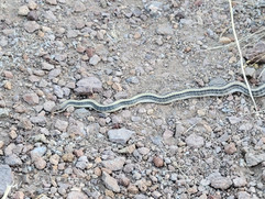
We connected to the North Star Trail from our campsite using the Backpacker Connector Trail, passing all the designated backpacking sites along the way. The trail delivered classic Superstition foothills terrain — rocky, open, and wild. Along the way we spotted a snake, non-venomous, crossing the trail.
The plant life along the trail is worth paying attention to. We identified Jojoba, Saguaro, Ocotillo, Barrel Cactus, Cholla, and Creosote Bush throughout the hike. One of the standout finds was a crested Saguaro — the rare fan-shaped mutation that affects roughly 1 in 150,000 plants. Finding one in the Superstition foothills on an October morning is exactly the kind of thing that makes you slow down and look more carefully at everything around you.
The North Star Trail climbs to the top of the mountain — and the views from the summit are the payoff. Looking out over the valley below, the scale of the Superstition wilderness becomes clear in a way that the desert floor never quite delivers. It's a proper summit view and worth every step of the climb to get there.


The Trails — Full Overview
The park has 9+ miles of multi-use non-motorized trails with varying difficulty — suitable for hikers, mountain bikers, and equestrians. The Backpacker Connector Trail links the campground directly to the main trail system, a smart design that means campers don't have to drive to a separate trailhead. The equestrian staging area makes this a popular destination for horse riders accessing the Superstition Wilderness from this side of the range.
The Stargazing Node
One of the more unusual amenities at Peralta Regional Park is the dedicated stargazing node — a level platform designed specifically for setting up a telescope. At this elevation and distance from city lights, the skies here are dark enough to make it worthwhile. If you're camping overnight, bring binoculars at minimum.
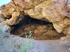
Day Two — Superstition Wilderness & Shaka Cave
After one night at Peralta Regional Park, we drove to the Superstition Wilderness and hiked to the Shaka Cave — one of the most rewarding short hikes in the greater Phoenix area.
The Shaka Cave trail is a lightly traveled primitive trail from the Ridgeline trail, sharing the same route as Wave Cave for the first 1.4 miles. The cave has relics like broken pottery, so Leave No Trace principles should be followed — please do not step on the metates (grind holes). The area was inhabited by indigenous people as much as 1,000 years ago, and later mined for copper by Pete Carney 100 years ago — rusted cans and other remnants are visible along the way.
The trail starts from Carney Springs Trailhead — the same trailhead used to reach Wave Cave. At the half-mile mark you'll come across a cattle gate — go through it. The Lost Goldmine Trail crosses perpendicularly here. The trail is well-defined but there are other trails going in different directions — bring navigation to keep you on the correct path.
The cave gets its name from the shaka symbol — the "hang loose" hand gesture from Hawaii. Standing inside the cave and looking out, the silhouette of the opening actually looks like the shaka hand symbol. It's one of those details that makes the destination feel earned. The hike is short enough to add a side trip to the Dacite mine, Wave Cave, or head up West Boulder to the ridgeline.


Practical Notes for Shaka Cave
The trail is 3.4 miles out and back, generally considered moderately challenging. The last stretch to the cave is steep with some scrambling — watch for loose rocks. Phone service is limited at the trailhead — download your map before you go. No fees to park at Carney Springs Trailhead.
More Information
Day use fee: $7 per vehicle, Ramada rental: $10/day individual, $35/day group — Pay Online or cash on site (exact change only) (2026)
Camping: $10/night individual sites, $35/night group sites — reserve at campspot.com/book/peralta-regional-park
America the Beautiful and Tonto National Forest passes NOT accepted — Pinal County fee only
Vehicles over 20 feet not permitted in camping areas
Gates lock at 10 PM (8 PM in summer) — overnight guests must check in before closing
Equestrian staging area available
Stargazing node on site — bring a telescope
#PeraltaRegionalPark #SuperstitionMountains #SuperstitionWilderness #ShakaCAve #GoldCanyon #ArizonaHiking #PinalCounty #ArizonaCamping #LostDutchman #CarneySpringsTrail #AZPlaces #PhoenixHiking #WaveCAve #ArizonaTrails #SuperstitionWilderness