
Tonto Natural Bridge State Park
AtoZ Places Bucket Location


Abandoned & Ghost Towns

Ancient Ruins

Caves

Desert

Forest

Historical

Hot Springs

Lakes & Rivers

National & State Parks

Peaks


Tonto Natural Bridge State Park near Payson, Arizona preserves the largest known natural travertine bridge in the world — a 183-foot high, 400-foot long arch spanning Pine Creek in a hidden canyon of Ponderosa pines, accessible via four short but steep trails that descend to the creek bed, the tunnel beneath the bridge, and swimming holes carved by centuries of mineral-rich water flow.
National & State Parks

Exploring

Hiking

Camping: None at location, dispersed sites nearby.
Camping: None at location.

FEE: Required
Visitor Center / Gift Shop

Water: Available at developed campgrounds. Pack in extra supply for dispersed camping.
More Info
Plants Foraged
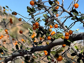
Spiny Hackberry
Nearby Locations
Christopher Creek Campground

Shoofly Village Ruins

Tonto Natural Bridge State Park
Hidden in a narrow canyon eleven miles north of Payson, the world's largest natural travertine bridge spans Pine Creek in a setting so lush and contained that first-time visitors frequently stop on the trail and simply stare. The bridge is 183 feet high and spans 400 feet across the canyon — formed over thousands of years by calcium carbonate-rich spring water depositing travertine mineral formations layer by layer across the creek. The result is a natural arch of remarkable scale in the middle of the Mogollon Rim country, with Pine Creek running through the tunnel beneath it and the canyon walls closing in on both sides.
Our Visit — March 21, 2022
Matthew, Luca, and I visited on March 21, 2022 — a March day that delivered exactly what this canyon does best in spring.
Before descending we noticed three trees near the visitor center covered in pink blossoms — the kind of detail that stops you before the main attraction even begins. Spring in the Rim Country arrives in bursts of color and the canyon rim above the bridge is no exception.
We took the Waterfall Trail and the Gowan Trail down to the creek. The Gowan Trail delivered the full experience — passing through the tunnel beneath the bridge itself, the travertine arch above you and Pine Creek running through at your feet. Walking beneath the world's largest natural travertine bridge is one of those moments where the scale of the thing registers differently than any photograph or description prepared you for.
We spent time below the bridge — some rock scrambling along the creek bed, exploring the travertine formations up close, and simply sitting with the canyon. The combination of the bridge above, the creek running through, and the canyon walls on both sides creates an enclosed, almost cathedral quality to the space below. There's no hurry in a place like that.
After making the climb back out we had a picnic on the grounds above — the Goodfellow homestead property with the lodge and the canyon rim views. A proper end to a morning in the canyon.
How the Bridge Formed
Tonto Natural Bridge is a travertine bridge — a specific and relatively rare geological formation created not by erosion but by deposition. Calcium carbonate-rich spring water flows over and through the rock, depositing mineral layers that accumulate over thousands of years into solid travertine stone. The bridge grew from the bottom up and from the sides inward until it spanned the creek completely. The process is the same one that creates stalactites and stalagmites in caves — applied at the surface and over a much larger scale. Estimates suggest the bridge is between 100,000 and 1 million years old. It is still actively growing.
The Discovery — David Gowan, 1877
In 1877 a Scottish prospector named David Gowan was being pursued by Apache warriors and hid in the canyon beneath the bridge. He emerged alive, returned to the area, homesteaded the land above the bridge, and eventually brought his nephew James Douglas Goodfellow and his family to settle here. The Goodfellow family built the stone lodge above the bridge — the structure still standing at the park — and maintained a working farm and eventually a tourist operation for decades. Arizona State Parks purchased the property in 1978. The Goodfellow Lodge remains on the grounds.
The Trails
Four trails descend from the rim to the creek level — all are steep, all involve loose footing, and none allow pets or strollers. A walking stick is recommended on all descents.
Anna Mae Trail — 0.3 miles, the most accessible trail to the bridge viewing area and the creek. Steep descent with uneven footing. Named for a family member of the Goodfellow homestead. Gets to the water fastest and offers the best direct view of the bridge from below.
Gowan Trail — 0.4 miles, descends through a riparian corridor to the creek bed below the bridge. Views of the bridge from multiple angles including underneath. The trail passes through the tunnel beneath the bridge itself — walking through the travertine arch is one of the most memorable moments at this park.
Pine Creek Trail — follows the rocky creek bed with close-up views of the travertine formations along the water's edge. Requires scrambling over boulders in some sections. The travertine pools and formations along the creek floor are exceptional up close.
Waterfall Trail — shortest descent, leads to a waterfall on the north side of the bridge. Seasonal — flow depends on rainfall and spring output. Worth checking current conditions before making this the primary destination.
Swimming
Swimming is permitted at designated areas in Pine Creek below the bridge — the travertine pools carved by centuries of mineral-rich water are cold, clear, and one of the more unusual swimming experiences in Arizona. The water is 60–65°F year-round from the spring inflow — genuinely cold regardless of air temperature. The swimming areas are reached via the Anna Mae or Gowan trails.
Wildlife and Plant Life
The canyon microclimate created by Pine Creek and the bridge's shade supports a lush riparian community unusual for the elevation. Mule deer, javelina, and a variety of birds inhabit the canyon. The combination of riparian vegetation along the creek, Ponderosa pine on the canyon rim, and the travertine formations themselves creates a layered habitat rarely found in such a compact area. Spring visits deliver wildflowers on the rim and the full effect of the green canyon against the tan travertine.
The Goodfellow Lodge
The historic stone lodge on the rim above the bridge was built by the Goodfellow family who homesteaded this property in the late 1800s. It is now an interpretive structure open to visitors — the interior shows the homestead era furnishings and interpretation. Worth stopping at before or after the trail descent.
No Camping in the Park
No camping is permitted within Tonto Natural Bridge State Park — day use only. The nearest camping is in the Tonto National Forest along AZ-87 north of Payson. Christopher Creek Campground sits approximately 10 miles east on AZ-260 and is the most popular nearby developed campground.
Additional Information
No camping is allowed inside the state park, camping available nearby in the Tonto National Forest.
Admission: Adults (14+) $10 / Youth (7–13) $5 / Children 6 and under free (2026)
Hours: 9:00 AM – 5:00 PM; last entry 4:00 PM; trails close one hour before park closes (2026)
Dogs are not allowed on hiking trails; recreational drones prohibited
#TontoNaturalBridge #TontoNaturalBridgeStatePark #TravertineBridge #PineCreek #Payson #ArizonaStatePark #AZStatePark #ArizonaHiking #NaturalArch #AZPlaces #GilaCounty #ArizonaParks #MogollonRim #WaterfallArizona #ArizonaAdventure
Arizona
Tonto Natural Bridge State Park, Nf-583A, Pine, AZ

Gila County
34°19'21.8"N 111°27'15.4"W
Elevation: 4,530 feet
Directions
From Phoenix, AZ: Take AZ-87 North (Beeline Highway) through Mesa, Fountain Hills, and Payson. Continue north approximately 10 miles past Payson and turn onto Forest Road 583A / Tonto Natural Bridge Road. Follow the posted signs to the park entrance. Fill up on fuel and water before leaving Payson — services are limited beyond that point. (~100 miles, ~1 hour 45 minutes)
From Payson: Head north on AZ-87 approximately 10 miles. Turn left onto Tonto Natural Bridge Road / FR 583A and follow signs to the park.


Best Seasons & Temperatures
Spring and fall are the ideal seasons — March visits as we experienced deliver cool temperatures, green canyon vegetation, and the bridge in its most photogenic light. Spring wildflowers bloom on the rim and the creek runs at its fullest from winter and spring rains. Summer visits are possible but the descent trails are exposed and heat builds quickly — go early morning and be off the trails by 11 AM in July and August. The park may close during monsoon season due to flash flood risk in the Pine Creek canyon — check current status before visiting July through September. Fall brings cooler temperatures and excellent light for photography of the travertine formations. Winter visits are quiet and beautiful — the park remains open in winter except during icy conditions, and the swimming holes are for the brave only. The descent trails require caution in any season — loose footing, steep grades, no pets, no strollers.
Tonto Natural Bridge State Park, Arizona
March 21, 2022