AZ Places
480-485-7233
Contact@AZplaces.com
www.AZplaces.com

Camping stay limit: 7 days per visit, 14 days per year
Cell service may be limited — download maps before you go
Dogs should remain on leash.
Fire Restrictions: No open fires — charcoal grills only at campgrounds
Free entry — no fees for parking, camping, or ranger-led tours
Water: Bring your own. Potable water may be available at the nearby campground.
Details
Spring
Mid February through Late April
Dry Summer
May and June
Fall
October through Mid December
Best Seasons
Kayenta Health Center
Nearest Hospital
Nearest Convenience Store
Navajo National Monument
Arizona
AZ-564, Shonto, AZ 86054, USA
Navajo County
Elevation: 7,300 ft
Directions
From Flagstaff, AZ: Take US-89 North approximately 75 miles to Cameron. Continue north on US-89 to US-160 East toward Kayenta. Follow US-160 East approximately 60 miles to AZ-564 North. Turn left on AZ-564 and follow 9 miles to the monument entrance. Total from Flagstaff: ~145 miles, ~2 hours 30 minutes.
Address: AZ-564, Shonto, AZ 86054, USA | (928) 672-2700 | nps.gov/nava
Campground
Camping
Hiking
Navajo National Monument
Navajo National Monument in northern Arizona preserves three of the most intact Ancestral Puebloan cliff dwellings in the Southwest — Betatakin, Keet Seel, and Inscription House — set within the dramatic Tsegi Canyon system on the Navajo Nation, with free entry, free camping, and ranger-led tours to dwellings last occupied around 1300 AD.
There are places in the American Southwest where the silence is thick enough to feel. Navajo National Monument is one of them. High on the Shonto Plateau in northern Arizona, overlooking the Tsegi Canyon system, this is where the Ancestral Puebloan people built homes in sandstone alcoves so well-chosen and so carefully constructed that they still stand more than 700 years later.
For centuries, the Hopi, San Juan Southern Paiute, Zuni, and Navajo people have lived in these canyons. Springs fed farmlands on the canyon floor and homes were built in the natural sandstone alcoves. The cliff dwellings of Betatakin, Keet Seel, and Inscription House were last physically occupied around 1300 AD — but the villages have a spiritual presence that can still be felt today.
The monument is situated on a plateau between Navajo Mountain, 30 miles to the northwest, and Black Mesa, 20 miles to the southeast. Being at the transition zone between the Sonoran and Great Basin deserts, the climate is hot and dry, but mitigated by an elevation of 7,300 feet — winters can be very cold with occasional snow; summer nights can be cool.
The park is entirely free — no entry fee, free camping, free ranger-led tours. One of the best deals in the National Park system.
The Three Cliff Dwellings
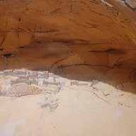
Betatakin was inhabited from about 1250 to 1300. The large south-facing alcove provided shade from the summer overhang and winter warmth from the lower sun. Betatakin once had 135 rooms, some destroyed by rockfall, and probably housed up to 125 people.
Keet Seel — the largest of the villages at Navajo National Monument — is also one of the best preserved cliff dwellings in the Southwest. People lived here from as early as 950 AD and by 1272, some 150 families lived there. Like Betatakin, by 1300 it was deserted.
Inscription House has been closed to the public since 1968 due to its fragile and unstable condition. Its remote location and fragility make public access impossible for the foreseeable future.
All Three Self-Guided Trails
Three trails are open until sunset and can be accessed behind the visitor center:
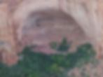
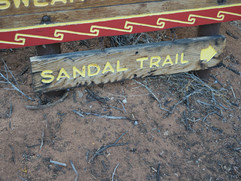
Sandal Trail — 1.3 miles round trip, paved, elevation loss up to 150 feet. Leads to the Betatakin overlook — the only self-guided view of the cliff dwelling.
Aspen Trail — 0.8 miles round trip, elevation loss up to 350 feet. Ends at an overlook of the relict forest at the bottom of Betatakin Canyon. Cliff dwellings not visible from this trail.
Canyon View Trail — 0.8 miles round trip, flat with no elevation loss. Follows the canyon rim from the visitor center to the park's historic ranger station. No cliff dwelling views but good canyon scenery.
The Sandal Trail — Our Hike
We hiked the Sandal Trail on September 6, 2025 — a self-guided 1.3-mile round trip from the visitor center to the overlook of Betatakin Ruins. The trail is paved with an elevation loss of up to 150 feet and is the only point in the park where the cliff dwellings can be seen aside from the guided tours.
Along the hike we identified native plants thriving in this high-desert environment — Pinyon Pine, Utah Juniper, Mormon Tea, Roundleaf Buffaloberry, Cliff Rose, Biocrust (Cryptogamic Soil), and Scarlet Gilia. Take time with the plants along this trail — the interpretive signage is well done and the plant diversity at this elevation transition zone is genuinely interesting. Bring binoculars for the overlook — the dwelling is across a 560-foot deep canyon and distance binoculars make the architectural details visible.


Ranger-Led Tours — Getting Closer
For those who want to get close to the dwellings rather than view from the overlook:
Betatakin Guided Tour — 5 miles round trip, approximately 5 hours, departs the visitor center at 8:15 AM MDT. Up to 25 visitors per tour, first-come basis, Memorial Day through Labor Day only. No fees charged. Strenuous — bring water and prepare for a significant hike. The tour group does not enter the village due to falling rock hazard but gets close enough to see significant architectural detail.
Keet Seel Guided Tour — 17 miles round trip backcountry hike. Can be completed in one day or with an overnight stay at the designated campground near Keet Seel. The hike has steep canyon switchbacks and sand dunes — after heavy rains, some areas can turn to quicksand. Once you arrive, a backcountry ranger takes small groups into the village. Reservations required — up to 20 people per day. Register starting in March for the summer season. Call (928) 672-2700.
Betatakin and Keet Seel tours are available during the summer season — Memorial Day through Labor Day.
Navajo National Monument Campgrounds
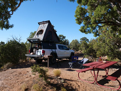
Canyon View Campground — Our Camp
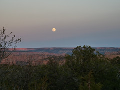
We camped at Canyon View Campground, Site 12 — a perfect spot with an open view looking toward Tsegi Point and the canyon country beyond. The day wrapped up with a sunset over the canyon that was the ideal close to the whole experience. Campsites have picnic tables and charcoal grills. Wood fires are not allowed. The campground is free, first-come first-served, and open year-round weather permitting.


Sunset View Campground
The second campground at the monument is Sunset View Campground — the larger of the two and the only one with potable water available outside the restrooms at the sink during non-winter months. Water is unavailable during winter months. Also first-come, first-served and free. Both campgrounds are limited to 7 days per visit and 14 days per year.
The Visitor Center Museum & Exhibit
After the hike we visited the visitor center museum — artifacts, cultural displays, and exhibits that bring the history of the canyon people to life. The visitor center includes an information desk, museum, auditorium, and park store. Open daily 9:00 AM–5:00 PM, closed Thanksgiving, Christmas, and New Year's Day. Well worth an hour before or after hitting the trails.


#NavajoNationalMonument #Betatakin #KeetSeel #AncestralPuebloan #CliffDwellings #NavajoNation #ArizonaHistory #NorthernArizona #AncientRuins #NationalMonument #AZPlaces #FreeParking #SandalTrail #TsegiCanyon #ArizonaAdventures