

AtoZ Bucket List
"Where have you been?"
Desert
AZ Places
National & State Parks
Peaks
Caves
Forest
Abandoned & Ghost Towns
Lakes & Rivers
Hot Springs
Historical & Ancient Ruins
Places Directory
This directory contains a history of various places for camping and exploring throughout Arizona and Utah. Locations within the directory are sites I have personally travelled to with family, friends or just myself.

No plants found matching your search. Try adjusting your filters.
Navajo National Monument


Navajo National Monument in northern Arizona preserves three of the most intact Ancestral Puebloan cliff dwellings in the Southwest — Betatakin, Keet Seel, and Inscription House — set within the dramatic Tsegi Canyon system on the Navajo Nation, with free entry, free camping, and ranger-led tours to dwellings last occupied around 1300 AD.
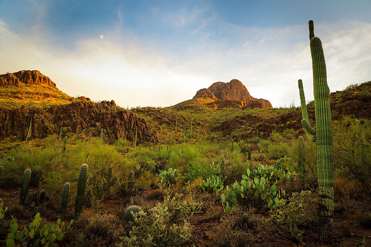
Saguaro National Park East

Saguaro National Park East — the Rincon Mountain District — protects one of the densest saguaro forests on earth alongside the 8-mile Cactus Forest Drive, 128 miles of hiking trails, and a wilderness backcountry that climbs from Sonoran Desert to pine forest at 8,666 feet in the Mica Mountains.

Titan II Missile Interpretive Site

The Titan II Missile Interpretive Site inside the Ironwood Forest National Monument near Marana, Arizona is one of 18 former nuclear missile launch sites that once ringed Tucson during the Cold War — a decommissioned silo where a 9-megaton warhead sat on 58-second launch readiness for over 20 years, now open to the public as a free interpretive site.
Mount Graham (Pinaleño Mountains)

Mount Graham — the 10,720-foot summit of the Pinaleño Mountains — is Arizona's tallest sky island range in the Coronado National Forest near Safford, offering dramatic elevation changes, ancient mixed-conifer forest, Riggs Flat Lake, and some of the most diverse wildlife in North America including the endangered Mount Graham red squirrel.
Sheep Bridge Hot Springs

Sheep Bridge Hot Springs is one of Arizona's most remote natural soaking spots — a 99°F geothermal spring on the banks of the Verde River in the Tonto National Forest, reached only by a rugged 4x4 drive through Bloody Basin or a long backcountry hike.
Anasazi Inn & Painted Desert Project

The abandoned Anasazi Inn at Gray Mountain, Arizona has been transformed by the Painted Desert Project into a striking outdoor mural gallery — large-scale street art and wheat-paste photography covering the weathered walls of a forgotten roadside motel along Highway 89 on the Navajo Nation.
Shoofly Village Ruins

Shoofly Village Ruins near Payson, Arizona is one of the most accessible ancient archaeological sites on the Mogollon Rim — a 4-acre prehistoric compound with 80+ rooms, a surrounding stone wall, and interpretive signs that bring a 1,000-year-old community back to life.
Silver Bell Cemetery

Silver Bell Cemetery is a historic frontier graveyard tucked inside the Ironwood Forest National Monument near Marana, Arizona — the last visible remnant of the original Silverbell mining community that boomed and went bust in the early 1900s.
Black Canyon Lake

Black Canyon Lake is a scenic 78-acre trout fishing lake on the Mogollon Rim in the Apache-Sitgreaves National Forest — a quiet alternative to the more visited Rim Lakes, with forested shoreline, electric motor boating, and wild horses known to stop at the water's edge.
Sasco Ghost Town

Sasco Ghost Town near Red Rock, Arizona is the crumbling remains of a Southern Arizona copper smelting operation from the early 1900s — featuring the ruins of the Rockland Hotel, smelter foundations, and a fascinating piece of Arizona mining history off the beaten path.

Pinal Mountains

The Pinal Mountains rise to 7,848 feet just south of Globe, Arizona — a sky island of ponderosa pine and white fir tucked inside the Tonto National Forest, offering cool summer camping, eight hiking trails, sweeping views from the lookout tower and some of the most surprising wildlife encounters in central Arizona.
Willow Springs Lake

Willow Springs Lake is the second most visited lake on the Mogollon Rim — a beautiful 158-acre reservoir set in the ponderosa pine forest at 7,500 feet, offering excellent trout and bass fishing, kayaking, and one of the most scenic shoreline views on the rim.
Woods Canyon Lake

Woods Canyon Lake is the most popular and accessible lake on the Mogollon Rim — a beautiful 158-acre reservoir surrounded by ponderosa pine, stocked weekly with rainbow trout, and equipped with a general store and boat rentals for a full day on the water.
Black Canyon (FR 300)

Black Canyon Rim Road (FR 300) winds through the cool, pine-covered high country of Arizona’s Mogollon Rim region, offering a peaceful escape surrounded by towering ponderosa forests. Located just minutes from Black Canyon Lake and only 12 miles from Willow Springs Lake, this area is ideal for dispersed camping, trout fishing, hiking the historic General Crook Trail, and visiting landmarks like the Pleasant Valley War gravesite. Frequent wildlife sightings—such as wild horses, elk, and bears—add to the adventure in this quiet, off-the-beaten-path destination.

Palatki Heritage Site

Palatki Heritage Site is one of the largest and best-preserved Sinagua cliff dwelling complexes near Sedona, Arizona — featuring ancient rock art, pictographs up to 6,000 years old, and guided tours through red sandstone alcoves in the Coconino National Forest.
Saddle Mountain

Discover Saddle Mountain in Tonopah, Arizona, a hidden gem for rock hounds, hikers, and outdoor enthusiasts. This stunning desert landscape offers chalcedony and quartz hunting, vibrant sunsets, petroglyph exploration—perfect for a unique desert adventure.
Chevelon Canyon Lake

Chevelon Canyon Lake, nestled on the Mogollon Rim in northern Arizona, is a serene, hidden gem offering fishing, hiking, and camping. Accessible via a challenging hike, this narrow reservoir is surrounded by rugged canyon views, perfect for nature lovers seeking adventure.
Ironwood Forest National Monument

Ironwood Forest National Monument is a protected area located in southern Arizona, United States. It was established in 2000 and covers approximately 129,000 acres of Sonoran Desert landscape. The monument is named after the iconic ironwood trees (Olneya tesota) that grow within its boundaries.
Old Rim Road (FR 171)

Escape into Arizona’s rugged high country along FR 171 and Young Road, where peaceful pine forests, dispersed campsites, and rim-edge views invite backcountry adventure. Located within easy reach of Willow Springs Lake for fishing and picnics, this quieter alternative to the main Rim Road is perfect for wildlife watching, off-grid camping, and exploring the cool, scenic landscapes of the Mogollon Rim region.

Moqui (FR 95)

FR 95 is a 30-mile forest road corridor through the Coconino National Forest below the Mogollon Rim — offering some of the best dispersed camping in Arizona, with nearby access to East Clear Creek, the historic Moqui Lookout fire tower, Blue Ridge Reservoir, water play in Barbershop Canyon, and miles of ponderosa pine backcountry to explore.
Petrified Forest National Park

Petrified Forest National Park in northeastern Arizona preserves one of the world's largest and most colorful concentrations of petrified wood — 225 million years old — alongside the sweeping multicolored badlands of the Painted Desert, ancient petroglyphs, and Ancestral Puebloan ruins across 93,500 acres.
Apache Lake

Apache Lake, located in the Tonto National Forest, is a scenic reservoir offering both developed and dispersed camping options. Surrounded by steep canyon walls and accessible via the historic Apache Trail, it’s a hidden gem perfect for camping, boating, and outdoor adventures. The Burnt Corral Campground provides 76 campsites, and visitors can also enjoy secluded dispersed campsites with stunning views of the lake and desert landscape.
Blue Ridge Reservoir

Camping near C.C. Cragin Reservoir offers a unique escape into nature, where you can enjoy peaceful solitude surrounded by rugged canyon walls, serene waters ideal for kayaking, and the thrill of fishing for rainbow trout, all while being immersed in the diverse wildlife and scenic beauty of the area.
Verde Hot Springs

Verde Hot Springs is one of Arizona's most storied remote soaking destinations — the ruins of a 1920s resort along the Verde River in the Tonto National Forest, where two natural hot spring pools survive among graffiti-covered walls and concrete foundations, reached by a rough 19-mile dirt road and a river crossing.


Bear Springs | Sunny Park (FR 124)

Discover the beauty of Arizona along Forest Road 124 in the Apache-Sitgreaves National Forest. This scenic destination features rugged forest terrain, towering ponderosa pines, and open meadows dotted with vibrant wild mushrooms. Visitors can also witness burn scars from the historic Rodeo-Chediski Fire, now blending with vibrant new growth—a powerful testament to nature's resilience. Wildlife you may encounter include wild horses, jackrabbits, deer, foxes, and squirrels.
Tonto National Monument

The Salado Phenomena, 700 years ago, blended ideas of neighboring Native American cultures to emerge a unique and vibrant society. Tonto National Monument showcases two Salado-style cliff dwellings. Colorful pottery, woven cotton cloth, and other artifacts tell a story of people living and using resources from the northern Sonoran Desert from 1250 to 1450 CE.
Happy Jack (FR 81)

Happy Jack, located in the Mogollon Rim Ranger District of the Coconino National Forest, offers a peaceful escape for dispersed camping. With its cooler summer temperatures, towering pines, and diverse wildlife, it’s a perfect destination for outdoor exploration and relaxation.
Gleeson Ghost Town

Gleeson Ghost Town is one of southeastern Arizona's most atmospheric abandoned mining communities — featuring the ruins of a hospital, saloon, school foundation, and a restored 1910 concrete jail turned museum, set against the dramatic backdrop of the Dragoon Mountains.
Courtland Ghost Town

Nestled in an arid landscape, Courtland, born from early 1900s mining fervor, whispers tales of a once-thriving community. A fading jail, a collapsing store, and silent foundations stand as echoes of its past. The hills, marked by mines, caution visitors of the hidden hazards within the remnants of Courtland's mining legacy.
Casa Grande Domes

The Domes of Casa Grande was four massive structures located in Casa Grande, Arizona, that were built to facilitate the manufacturing of computers in the late 1970s and early 1980s. However, the project was never completed, leaving behind only a few foundations that were started and left to molder. One of the buildings is shaped like a flying saucer, and the other three resemble spheres joined together. Despite their abandoned state, the Domes remain a popular destination for urban explorers and photographers, drawing visitors to their otherworldly appearance.
Walnut Canyon National Monument

Discover the awe-inspiring Walnut Canyon National Monument near Flagstaff, Arizona, where ancient cliff dwellings and breathtaking canyon vistas invite you to step back in time. Hike along scenic trails, spot unique wildlife, and immerse yourself in the rich cultural and natural history of this remarkable destination.
Alamo Lake Wildlife Area

We spend several nights here on the edge of the lake. Enjoyed listening to the water and the birds while siting by the fire. Really great spot for camping. Nice and secluded beaches and peninsulas with beautiful views of the lake and surrounding mountains. A lot of fishermen in boats trolling, lake is well known for bass fishing. Looking forward to return with our kayaks. While in the area we visited the Alamo Dam and made a stop for ice-cream at the ranger store at the Alamo State Park. On our drive there we saw wild burros.
Aztec Ruins National Monument


Aztec Ruins National Monument in New Mexico is home to a complex of ancient ruins built by the ancestral Puebloans over 900 years ago. As I walked through the park, I was struck by the impressive masonry of the structures and the rich history and culture they represent.
Chaco Culture National Historical Park

This Chaco Canyon Valley, high-desert landscape has long winters, short growing seasons, and marginal rainfall. Yet, it became the center of a thriving culture a thousand years ago. It was an unlikely place for a major center of ancestral Puebloan culture to take root and flourish. The grand scale of its architecture is monumental, making it a center hub for far-reaching commerce with complex community life and high levels of social organization, creating a cultural vision unlike any other seen before or since. That began in the mid 800s and lasted more than 300 years. Their descendants are the modern Southwest Indians. Many Southwest Indian people look upon Chaco as an important stop along their clans' sacred migration paths-a spiritual place to be honored and respected.
Mt Lemmon

Mount Lemmon is the crown of the Santa Catalina Sky Island — a 9,159-foot escape rising from Tucson's desert floor through six life zones to pine forest, dispersed camping, hiking, and the southernmost ski area in the United States, all accessible via the 27-mile Catalina Highway Scenic Byway.
Picacho Peak State Park

Picacho Peak State Park, located along Arizona's I-10 corridor, is a stunning desert destination known for its striking peak, hiking trails, and rich history. A favorite for outdoor enthusiasts, the park offers camping, wildlife watching, and breathtaking desert views.
Topaz Internment Camp & Museum


Topaz Internment Camp near Delta, Utah is the site of one of the largest WWII Japanese American internment camps — where nearly 8,000 American citizens were confined from 1942 to 1945. A small museum in Delta preserves their story.
Anasazi Ridge Petroglyphs

The Temi' Po' Op' petroglyph site near Ivins, Utah offers a family-friendly 2.9-mile hike along the Santa Clara River to hundreds of ancient rock art panels, an Anasazi farmstead foundation, and sweeping views of the red rock canyon — one of the highest concentrations of petroglyphs in southern Utah.
Organ Pipe Cactus National Monument

Explore the rugged beauty of Organ Pipe Cactus National Monument, a UNESCO biosphere reserve where vast desert landscapes meet striking mountain ranges. Discover rare flora, hike scenic trails, and experience the vibrant biodiversity of Arizona’s Sonoran Desert.
McFadden Peak

McFadden Peak, the site of one of two fire lookouts in the Sierra Ancha, offers continuous views of the surrounding areas. This peak was named for William McFadden, who started the Circle Ranch on McFadden Creek. McFadden had been part of a vigilante group during the Pleasant Valley War, and later settled in the Sierra Anchas to get away from the feud.
Tabernacle Hill Lava Tubes

Explore the Tabernacle Hill Lava Tubes in Utah, a captivating natural wonder located near Leeds. This unique geological formation offers adventure seekers a chance to hike, explore underground lava tubes, and take in scenic desert landscapes. Ideal for outdoor enthusiasts, photographers, and campers, the lava tubes are a must-see for those seeking an off-the-beaten-path experience in Southern Utah.
Red Cliffs Recreation Area

Red Cliffs Recreation Area near Leeds, Utah is a BLM gem tucked against dramatic red sandstone cliffs just off I-15 — featuring Early Jurassic dinosaur tracks in the sandstone, Ancestral Puebloan ruins, 14 hiking trails through Quail Creek Canyon, and one of the most visually striking campgrounds in southern Utah.
Silver Reef Ghost Town

Explore Silver Reef Ghost Town near Leeds, Utah, a once-thriving mining town uniquely built on silver-bearing sandstone. Founded in 1875 and abandoned by 1891, this historical gem offers a fascinating glimpse into the Wild West's mining past, scenic views, and family-friendly activities.
Baker Hot Springs

We first visited Baker hot springs in 1995 and went on and off through out the years while I lived in SLC. We last visited while traveling through Utah in 2017, we camped near the springs at that time there was one other camper. This gentlemen served us pancakes in the morning and told us he had spotted a white llama that came down from the hill to drink from the water. During our visit the water was flowing well and appeared the tubs have been well maintained, due to lack of algae. We found an additional pool in the area that could be dipped in as well as the tubs. There was once some abandoned buildings in the area, they since I believe have been destroyed. I look forward to visiting Baker hot springs again.
Colossal Cave Mountain Park

Colossal Cave Mountain Park has cave tours, hiking & biking, trail rides, camping & picnicking, terrace Café & gift shop. The campsites are tucked among the saguaro cacti and mesquite trees in Posta Quemada canyon. These grounds consist of two large areas, El Bosquecito and La Selvilla, both have water and restrooms. Additionally there are a number of smaller areas totaling 30 individual sites. Camping is first-come, first-served. This is primitive camping. No electricity or RV hook-ups available. are located in El Bosquecito and La Selvilla.
Two Guns

Two Guns is one of Arizona's most haunted and storied Route 66 ghost towns — a cursed stretch of Canyon Diablo where a Navajo massacre, a Wild West showman, a mountain lion zoo, a murder, and a devastating fire all converged on the same dusty patch of high desert east of Flagstaff.
Lava River Cave

This mile-long lava tube cave was formed roughly 700,000 years ago by molten rock that erupted from a volcanic vent in nearby Hart Prairie. The top, sides and bottom of the flow cooled and solidified first, after which the insides of the lava river continued to flow emptying out the present cave.
West Fork Campground

Discover West Fork Campground in the scenic Black River area of the Apache-Sitgreaves National Forest. At 7,740 feet elevation, this peaceful, undeveloped site offers dappled shade beneath towering pines, abundant wildlife, and opportunities for river play. Open from May to October, this free camping spot invites adventurers seeking a rustic, nature-immersed experience.
Bear Flat (FR 405)

Bear Flat is one of the Tonto National Forest's most rewarding and least-visited dispersed camping areas — easy forest road access through the pines near Payson, Arizona, with an old homestead site, a spring-fed canyon trail, wild blackberries and bear country solitude on FR 405 and 405A. Tonto Creek is a short drive away with access to a trail leading to the rugged Hellsgate Wilderness.
Twin Arrows Trading Post

Twin Arrows Trading Post a Route 66 roadside attraction was built in the late 1940's and was abandoned in 1995. It consists of giant yellow wooden twin arrows, an abandoned gift shop and Valentine’s diner, some gas pumps, and big tanks in the back still remain. The building and various structures are deteriorating, this Icon has certainly seen better days. From what I understand the land is owned by the Twin Arrows Navajo Casino, that appears have yet to cleanup the area. Now abandoned buildings and structures have become a canvas for graffiti artists. Lots of interesting and creative graffiti to explore.
Bear Canyon Lake

Bear Canyon Lake is one place we go most often. There are plenty of places to setup camp and lots to explore. We have never had a issue finding a spot to camp, at times can barely hear anyone around. We pass all the nearest sites near the lake and go past the powerlines where there are plenty of sites spread out. From there it is a bit of a hike to the lake, or short drive. Depending upon the season you can hear elk and coyotes in the area.
Meadow Hot Springs

Located just 4 miles south of Fillmore, Utah is the quiet little town of Meadow. Meadow Hot Spring is located just west of the town of Meadow, in an open field. The spring is located on private property, but the land owner has continued to make it accessible to the public. The property has been improved with fences and a nicely graded walking path that connects three different pools. The property owners have posted several signs at the main gate so please respect their wishes and obey the posted rules, this will ensure that this beautiful natural resource will remain open to the public.
Bradshaw City Ghost Town

Explore the historic ruins of Bradshaw City, a former gold-mining boomtown established in 1863 in Yavapai County, Arizona. Once home to nearly 5,000 residents, today it offers visitors a fascinating glimpse into Arizona's mining past, surrounded by beautiful forested landscapes.
Ruby Ghost Town

Just a day trip away from Tucson & 4 miles shy of the border of Mexico is a rare opportunity to look back at over a century of Arizona's mining history. From a once-thriving community of 1,200 people to a modern-day ghost town. Ruby has access to over 350 acres of trails, two lakes, and incredible biodiversity.