
Sears Kay Ruins
AtoZ Places Bucket Location


Abandoned & Ghost Towns
Caves
Desert
Forest
Historical & Ancient Ruins
Hot Springs
Lakes & Rivers
National & State Parks
Peaks


Historical & Ancient Ruins
Exploring
Hiking
Aware: Rattlesnakes possible
Camping: None at location.
Toilets: Vault toilets available.
Water: No potable water; pack in your own supply.
More Info
Have you been here?
Nearby Locations
Sheep Bridge Hot Springs

Sears Kay Ruins
Step back a thousand years at Sears Kay Ruins, one of the most accessible and historically significant prehistoric sites in the greater Phoenix area. The ruins are the remains of what was once a fortification of the Hohokam culture, located in the Tonto National Forest just outside the town of Carefree, Arizona. Wikipedia
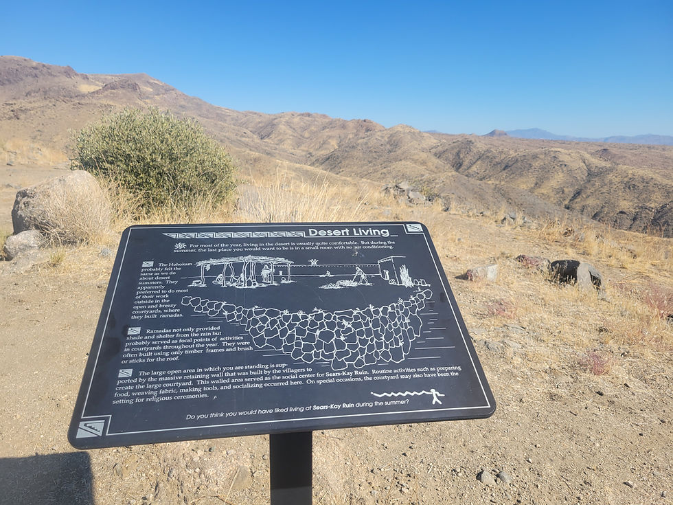
The fort was built around 1050 AD and had 40 rooms, which housed about 100 people. During the 12th and 13th centuries, fortified villages like Sears Kay appeared on the hilltops of the desert foothills — archaeologists believe the pattern reflects competition for resources, possibly land and water, with the villages built to protect the foothills from outside attacks. WikipediaWanderer Writes
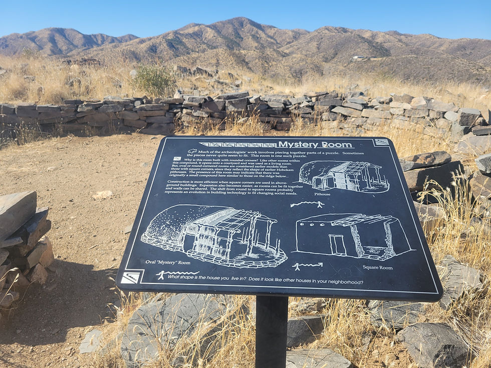
One of the most intriguing features is the "Mystery Room" — the only room among the 40 that does not have square corners. Its rounded corners have led archaeologists to speculate that it was built in an earlier period than the rest of the structure. Wikipedia
The desert foothills surrounding the ruins make up a transition zone between the Sonoran Desert to the south and the Colorado Plateau to the north, giving the area plants and animals from both regions. The Hohokam who lived here had access to deer, rabbit, and mountain sheep, along with desert staples like mesquite, saguaro, prickly pear, and cholla. They also farmed corn, beans, and squash. Wanderer Writes
In 1867, soldiers of the 5th Cavalry Regiment from nearby Fort McDowell rediscovered the fort while on patrol. The site was named Sears-Kay Ruin because it sat on the lands of the Sears-Kay Ranch, founded by J.M. Sears in 1887. On November 24, 1995, it was listed on the National Register of Historic Places. Wikipedia
The trail itself is easy enough for most visitors. The self-guided loop covers just under a mile with about 200 feet of elevation gain, typically taking 30 minutes to an hour. Interpretive signs along the route help bring the ruins to life, and views from the hilltop are outstanding — on a clear day you can see all the way to the Superstitions, Four Peaks, and the McDowell Mountains. AllTrailsArizonadayhikes
The site is a fee-free area with 3 ramadas, picnic tables, grills, trash service, and paved parking for 8 vehicles. Day use only, open 6:00 a.m. to 10:00 p.m. No trailers allowed. There are vault toilets at the trailhead but no running water. Dogs are welcome on leash. USDA
If you witness any looting or vandalism at this or any other archaeological or historic site, call 1-800-VANDALS.
#SearsKayRuins #HohokamHistory #ArizonaHiking #AncientRuins #GreatWesternTrail #HistoricArizona #PrehistoricSites #NationalRegisterOfHistoricPlaces #ArizonaAdventures #HikingNearPhoenix #TontoNationalForest #CaveCreekArizona #ArizonaHistory #DayHikeArizona #AZPlaces
Arizona
N Sears Kay Ruins Rd, Arizona 85331, USA

Maricopa County
33°53'08.4"N 111°48'57.8"W
Elevation: 3,031 ft
Directions
From Phoenix, AZ: Head north on the Loop 101 to Scottsdale Road. Continue north on Scottsdale Road until it ends at Cave Creek Road. Turn right (east) on Cave Creek Road (which becomes Seven Springs Road / FR 24) and drive approximately 9 miles to Sears Kay Ruins Road. Turn right into the trailhead parking area. Address: 40202 N Cave Creek Rd, Scottsdale, AZ 85262. (~55 miles, ~1 hour)
From Carefree: Take Cave Creek Road / Seven Springs Rd. / Forest Road 24 north for 14 miles to Sears Kay. Look for the entrance on the right

Sears Kay Ruins, Tonto National Forest, Arizona
November 15, 2024