
Howard Pocket (FR 536A)
AtoZ Places Bucket Location


Abandoned & Ghost Towns

Ancient Ruins

Caves

Desert

Forest

Historical

Hot Springs

Lakes & Rivers

National & State Parks

Peaks

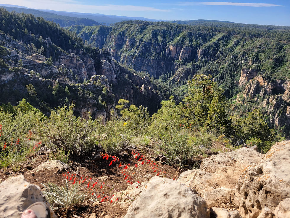




Howard Pocket is one of eight designated dispersed camping areas on the Coconino National Forest rim above Sedona — a ridge-top camp at over 6,000 feet with sweeping views of the Red Rock-Secret Mountain Wilderness, West Fork Oak Creek Canyon below, and a panorama stretching east to Oak Creek Canyon, I-17, and the fire towers of the Mogollon Rim country.
Forest

Wildlife

Hiking

Exploring

Camping

Bear Country: Store all food, scented items, and trash in bear boxes where provided. At dispersed sites without bear boxes, store food in a locked vehicle or hung from a tree away from camp.

Camping: Dispersed camping allowed up to 14 consecutive days.

Cell service may be limited — download maps before you go
Dogs should remain on leash
No Trash Services: Pack it in & Pack it Out
No campfires during fire restrictions — before visiting check with the Ranger District or BLM.

No facilities on site — no water, no restrooms
⚠️ Area currently closed — verify before visiting
More Info
Plants Foraged
Nearby Locations
Edge of the World (FR 231)

Howard Pocket (FR 536A)
Howard Pocket sits on a ridge above the Red Rock-Secret Mountain Wilderness — one of eight designated dispersed camping areas established by the Coconino National Forest west of Sedona following the 2022 restrictions that banned general dispersed camping within the Sedona buffer zone. The designated areas are the compromise — small, specific plots of land where free camping is permitted within the otherwise restricted zone. Howard Pocket is one of them, and among the eight it has the combination of rim-edge position, wilderness views, and enough separation from the others to feel genuinely remote.
We camped here June 7–8, 2026 — moving directly from Edge of the World on FR 231 for a third rim night before heading home.
The Setting — A Ridge Above the Wilderness
The Red Rock-Secret Mountain Wilderness encompasses 47,195 acres of wind and water sculpted pinnacles, windows, arches, spires, mesas, and canyon walls immediately below Howard Pocket's ridge position. The wilderness was designated in 1984 and marks the edge of the Colorado Plateau just east of Sycamore Canyon Wilderness. From Howard Pocket's ridge the wilderness spreads below — the rock formations and cliff faces the primary view, watching as the light moves across them through the day.

West Fork Oak Creek runs through the canyon directly below — but due to how narrow and tall the canyon is, and the vegetation growth along the rim, the actual river is not visible from the camping ridge. What you see are the canyon walls and the depth of the drainage cutting through the wilderness, with the knowledge that West Fork is down there in the green riparian corridor far below.
Our Visit — June 7–8, 2026
We scouted Howard Pocket on OnX before arriving and identified the best available site. On arrival we thought we were alone in the area — but exploring the ridge revealed a camper already set up at a neighboring site, one we had also scouted and considered. They passed our site the next day. Later two trucks came up to our site clearly hoping it was available — they assessed the situation and moved on. When you scout a location well and arrive with specific coordinates, that preparation pays off.
Our site at 35°01'35.6"N 111°48'26.5"W was the best of the available options for our needs. The other nearby designated sites trade off in different ways — one at 35°01'34.6"N 111°48'07.0"W is more exposed to wind, another at 35°01'32.4"N 111°47'10.5"W sits more in the trees with a short walk needed to access the open view.
The rock formations and cliffs were the main event — watching as the light changed across the Red Rock-Secret Mountain Wilderness throughout the day and evening. The wilderness below transforms through the hours: morning light hitting the east faces, midday bringing the full red color out of the sandstone, late afternoon turning the west-facing walls warm and deep. The transition from day to evening light on that rock is worth the entire drive.
The Panorama — What You Can See
The view east from Howard Pocket's ridge is as interesting as the wilderness view south and west. Two distinct canyon systems are visible to the east — Oak Creek Canyon running along AZ-89A is one, and the canyon carrying I-17 is another. Lights from Munds Park are visible at night in that eastern canyon. Sunlight reflecting off fire towers to the east catches the eye in the evenings as the sun is setting. The scale of the panorama — wilderness below, canyons east, Sedona to the south, rim country beyond — makes Howard Pocket feel like a genuine overlook into the full geography of central Arizona.
Pansy Tank and Bear Sign

I explored the ridge heading west on a hike — but with signs of bear in the area and hiking alone, opted not to go too far. The bear sign was real and close. We found Pansy Tank — a stock tank on the ridge — full of water and surrounded by animal tracks: large bird prints, deer, and bear clearly impressed in the mud around the edge. Bear prints in the sandy road right near our campsite confirmed the wildlife pressure in the area. This is genuine bear country — treat it as such, store food properly, and be bear-aware on any hike from camp.
The ridge hike heading west offers additional views into the wilderness and along the rim — worth doing in the morning with good light and company.
The Designated Dispersed Camping System
Howard Pocket is part of a system of eight designated dispersed camping areas established by the Coconino National Forest west of Sedona in September 2022, when a buffer zone ban on general dispersed camping went into effect. The designated areas are specific small plots — essentially primitive sites without infrastructure — where camping is still permitted within the otherwise restricted zone. Some of the eight designated areas are described as effectively dirt parking lots accommodating only a few vehicles. Howard Pocket's ridge position makes it one of the more rewarding of the eight.
Download the current Coconino National Forest dispersed camping map for the Sedona area before visiting — the designated areas and their boundaries are clearly marked. OnX is the most reliable tool for identifying specific site locations within these designated areas.
⚠️ CURRENT CLOSURE — POCKET FIRE
Howard Pocket and the surrounding Coconino National Forest west of Sedona are currently under closure order due to the Pocket Fire, which started June 19, 2026 — eleven days after our visit — and has grown to over 27,000 acres as of August 2026 with 95% containment. Do not attempt to access Howard Pocket at this time. Check current closure status at fs.usda.gov/r03/coconino/alerts before planning any visit.
#HowardPocket #CoconinoNationalForest #DispersedCamping #RedRockSecretMountain #SedonaViews #ArizonaCamping #FreeCamping #MogollonRim #AZPlaces #CoconinoCounty #WestForkOakCreek #DesignatedCamping #ArizonaWilderness #PocketFire #SedonaArizona
Dispersed Camping

Arizona
25GV+J3C Oak Creek Canyon

Coconino County
35°01'35.6" N, 111°48'26.5" W
Elevation 7,000 feet
Directions
Access via FR 535 / FR 536 corridor from AZ-89A:
From Sedona head north on AZ-89A toward Oak Creek Canyon. Approximately 1.2 miles past the switchbacks turn left onto FR 535. After 2.6 miles bear left to continue on FR 535. After 4.1 miles bear left onto FR 536. Continue on FR 536 toward the Howard Pocket designated camping area.
From Flagstaff via FR 231 / FR 535:
Access is also possible from the FR 231 (Woody Mountain Road) corridor connecting to FR 535 and FR 536 — the same general road network as Edge of the World.


Best Seasons & Temperatures
Late spring through fall is the primary season when forest roads are accessible in dry conditions. June visits are possible but fire risk at this elevation in dry years is significant — check fire restrictions and road closures before any visit. Summer monsoons make forest roads impassable after rain. Winter brings snow closures. The area is currently closed due to the Pocket Fire — check current status before planning any visit. Weekdays offer significantly better availability than weekends at all designated dispersed sites near Sedona. Download maps and coordinates before leaving cell service range.
Howard Pocket dispersed camping Red Rock Secret Mountain Wilderness Sedona Coconino National Forest rim view
June 7-8, 2026