


Chiricahua Mountains Road Trip — Cave Creek Canyon to Chiricahua National Monument
- Rachel Joel

- 4 days ago
- 13 min read
By Rachel Joel · AZ Places · Coronado National Forest, Arizona
There are corners of Arizona that most people never find. The Chiricahua Mountains are one of them — tucked into the far southeastern corner of the state, closer to Douglas than to Tucson, rising abruptly from grassland plains into one of the most biologically diverse sky island ranges in North America. We spent four days here in late April and early May 2026 — Matthew, Luca, and I — working our way through Cave Creek Canyon, up to Rustler Park, through Chiricahua National Monument, and out through the dispersed country along Pinery Creek.
It was the kind of trip where something unexpected happened every day. We planned for that. We weren't disappointed.
Day One — Portal, Dinner in the Rain, and Lightning in the Canyon
We arrived in Portal on the evening of April 30th with a storm on the horizon and a plan to find camp before dark. Portal is small — a handful of homes at the mouth of Cave Creek Canyon, including the Portal Peak Lodge Store and Cafe where we stopped for dinner. We sat outside at the patio tables as the storm built over the canyon walls. Matthew and I had sandwiches. Luca had pizza. The place was busy for such a remote location — birders mostly, which tells you something about what this canyon draws.

After dinner we drove toward the end of South Fork Cave Creek looking for a dispersed site. Prior to leaving Portal we seen a bobcat on the edge of the road, he crossed behind us, making it possible to capture a photo. The sign at the South Fork trailhead said No Camping — this area is day use only, protected for the Elegant Trogons and other sensitive bird species that nest here during spring and summer. With the rain starting in earnest and evening settling in we continued to Sunny Flat Campground.
At the very end of the campground loop we found what appeared to be one of the last available sites — and it was exactly right. A large slab with a ramada, picnic table, and bear box. Views of the canyon walls from the site. We parked, popped up the Alu-Cab rooftop tent, and Luca set up his cot under the ramada.
The rain came in fully and stayed for six hours. We didn't mind. We hung around under the ramada watching the mist move through the canyon, reading, snacking. At one point we pulled on rain gear for a walk to the fee station to pay our $20 and check the restrooms. I filled out my pay stub, found it difficult, being everything was wet. The kind of small camp errand that feels completely different in the rain.


The lightning started later in the evening. Six good strikes — and what happened to the thunder is something I still think about. It rolled both directions through the canyon simultaneously. When it hit a side canyon you could hear it split — going two ways at once. The sound traveled the full length of the canyon in both directions, echoing off the walls, before fading. I've never heard anything like it. We didn't record it. I wish we had an audio recording — the visual isn't the thing that stays with you, it's the sound.
We went to bed late, listening to the last of the rain on the tent.
Day Two — The Sunny Flat Trail, a Swimming Hole, and Herb Martyr's Waterfall
Blue sky the next morning. Muffins and coffee for breakfast. We had the site until 11 and used the time on the Sunny Flat Trail before breaking camp.
The trail starts at the end of the campground and works its way through the canyon vegetation — tall sycamores, oaks, junipers, and pines shading the path along Cave Creek. Along the way we found the explosive shacks — small structures built directly into the stone walls of the canyon with rock construction and metal doors. These were storage facilities for explosives used during the construction of the road through Cave Creek Canyon. Easy to walk past without noticing. Worth stopping for. The trail also had signage identifying native plants along the route — the kind of interpretive detail that rewards attention. A Fremont Cottonwood stood out among the trees, genuinely tall and striking in the canyon setting


We spotted a group of deer moving through the hillside vegetation and heard turkey calls in the distance from somewhere across the canyon. Later, while walking through the Idlewilde Campground area, we spotted a wild turkey in the open. We also noticed a campsite at Idlewilde next to a swimming hole — pinned it for a future visit.
After breaking camp we drove to the South Fork Trailhead — word had spread among birders that a rare species had been spotted in the area and people were gathering with cameras and long lenses. Rather than joining the crowd we drove back to the Idlewilde swimming hole, took a cold dip, and had lunch on the bank. Egg salad sandwiches on fresh baked bread, chips and salsa, cold sodas. The swimming hole was running cold and clear from the previous night's rain. We took the opportunity to take a dip. It was cold, but very refreshing.
After lunch we stopped at the Southwestern Research Station — a facility of the American Museum of Natural History that sits where the pavement ends in Cave Creek Canyon. We browsed the bookstore, looked at field guides, and each had an espresso. Talked with a former ranger. Small stop, worth it. This is the kind of place that makes a canyon road trip feel like more than just driving between campsites.
From the research station we turned left onto Forest Road 42A and followed it approximately four miles to the end of the road — Herb Martyr Campground.
We chose Site 4. The reason was immediately obvious — a 12-foot waterfall on Cave Creek sat just a short distance below the campsite. The waterfall is created by a series of rock dams built across the creek at various points, stacking the water up and dropping it over the edge.
We set up camp. Luca set up his cot and worked on practicing different methods of setting up a rain cover using a tarp — a skill he wanted to develop for open camping. We gathered what firewood we could find and had brats and vegetables over a small fire as evening settled in. A wild turkey walked through camp while we were cooking — crossed the creek without hesitation and worked its way up the steep slope on the far bank at a pace that suggested it knew exactly where it was going. After dinner Luca turned in early and Matthew and I sat by the river in the dark until late — the waterfall audible the whole time.


The next morning I woke early and hiked back up the canyon with my camera before the others were up. Returned to camp for a simple breakfast — cold cereal, fruit, coffee. Then we took one more walk along the lower river, following the rock dams downstream and finding more pools, more structure, more of the creek at its best. We still don't know when those dams were built or why. The mystery of a place is sometimes better than the answer.
Day Three — Rustler Park, Barefoot Park, and Pinery Creek
We left Herb Martyr and drove south and west, stopping to confirm dispersed camping spots we had scouted on OnX before the trip. Along FR 42 toward Onion Saddle we marked six potential dispersed camp locations. At Onion Saddle — 7,619 feet — we turned toward Rustler Park.

The campground sits at 8,400 feet in a wildflower-carpeted meadow rimmed with Douglas-fir and ponderosa pine. The campground has been rebuilt since the catastrophic Horseshoe 2 Fire of 2011 burned through here — consuming the tree canopy and destroying the Barfoot Lookout tower entirely. Some sites now have shade canopies installed as a result. The downed trees and fire scars are still visible throughout — the forest is recovering but slowly. Two major wildfires in 20 years have fundamentally changed what Rustler Park looks like.

We noted it as a strong future destination for night sky viewing — the elevation and distance from city lights make it one of the better dark sky locations in this part of Arizona. Ranger station cabins sat under some of the remaining trees. We tried to spot Barfoot Lookout from the road on the drive in and out without success. Learned later why — the tower was destroyed in the Horseshoe 2 Fire and what remains is only a foundation and block walls, which explains why it wasn't visible from the road. The trailhead to the Barfoot Lookout is at Barefoot Park,
We took FR 357 (Pine Canyon Road) to check out Barefoot Park — a National Natural Landmark down the road from Onion Saddle. The area appeared to see limited use. Picnic tables scattered in odd locations. Large old foundations and a small shed behind a fenced meadow — remnants of a former Boy Scout camp that once operated here, including a chapel built by the Kiwanis Club of Douglas in 1962. We didn't drive much further due to muddy road conditions after the rain.


What the modest appearance doesn't reveal is the significance of the place. Barfoot Park was designated a National Natural Landmark the same month the Horseshoe 2 Fire burned through it in June 2011 — an almost impossibly bad coincidence. The park supports an unusual mix of Sierra Madre and Rocky Mountain flora including four pine species and 18 other tree species, three meadows, two permanent springs, and more than 15 acres of talus slopes. Those talus slopes are the US epicenter for the Twin-spotted Rattlesnake — one of the rarest rattlesnakes in North America. The Pine Satyr butterfly, which barely reaches the US from Mexico, also lives here. The fire damaged it significantly but the recovery is ongoing. It deserves a proper visit on a dry day.
Heading out of Barfoot Park we stopped to talk with a man attending to gear on the roadside — he was from Utah and suggested we check out FR 42C near Pinery Creek. OnX listed it as Methodist Camp. He mentioned it was a decent road most of the way with one washed-out section that was still passable.
We found the washed-out section and knew we were in the right place. A short distance further was an excellent dispersed campsite on Pinery Creek at approximately 6,160 feet — views of the cliffs, established fire rings, firewood available to gather.
The campsite had a large standing dead tree with holes covering it all the way up the trunk — no branches remaining, just a column of drilled holes from bottom to top. A classic granary tree. Luca spotted a bird pulling something from one of the holes and flying off. We watched this continue throughout our stay. This was our introduction to the Acorn Woodpecker.


The Acorn Woodpecker is one of the most distinctive birds in the American West — a clown-faced woodpecker with a bold red cap, white forehead, black back, and yellow eyes that give it a permanently startled expression. What makes it remarkable is what it does. It lives in cooperative family groups of up to 15 individuals and builds what are called granary trees — dead or dying trees drilled with thousands of individual holes, each the right size for a single acorn. The birds harvest acorns in fall, wedge them tightly into the holes, and tend the granary constantly — checking holes, moving acorns to better-fitting spaces as they dry, and defending the whole operation fiercely against squirrels, jays, and competing groups. A single granary tree can contain up to 50,000 stored acorns and may be used by multiple generations of the same family group for decades.
We set up camp, gathered firewood, had a late lunch of sandwiches. Walked down the road to check other available sites — ours was the best in the immediate area.
One note that needs to be said plainly. Someone had left bags of human waste on the riverbank near our site. Not what anyone wants to deal with upon arrival — cleaning up someone else's mess, especially that. If you cannot dig a proper cat hole, going on the ground away from water is still preferable to bagging waste and leaving it at a campsite near a river. Please pack out waste properly or follow Leave No Trace principles. This is a beautiful and rarely visited canyon — it deserves better.
After dark we enjoyed the campfire for many hours. Luca had setup his cot next to the fire in the open. Matthew and I stepped away briefly and heard a loud scurry — something jumping across the river. Luca woke fully from a sound sleep, startled with an adrenalin rush. We never identified the animal. My trail cam had been set up across the creek for exactly this — but a low-battery IR failure meant nothing was captured. Frustrating. After the excitement settled we stayed by the fire a bit longer before heading to bed.
Day Four — Downing Pass, the Carved Cave, and Chiricahua National Monument
The next morning Luca and I rose early and hiked off-trail from camp — up from 6,160 feet to the cliffs at approximately 6,400 feet on Downing Pass.


Small pools of water with thick moss beds. Cactus in flower. Birds. Black-colored lizards on the rock faces. Cut-down power poles and a broken ceramic insulator — one foot wide, the kind used on high-tension lines. A large rock that looked like petrified wood. We're still not sure.


We descended, walked the road back to camp, and took a cold dip in the river before packing up. On the way out we stopped at a cave noted on the drive in — a short walk from the road to a cavity carved into the rock with a metal door frame. Inside: a wooden air vent system, evidence of an old campfire, a bat roosting in the corner. A place with obvious history and unclear purpose.


We continued on to Chiricahua National Monument, during the drive we saw many Turkeys. Our first stop upon arrival at 2:00 PM, was the visitor center — museum exhibits, trail maps, conversation with rangers, real restroom. We picked up a map of the Chiricahua Mountains and the usual keepsakes: sticker, pin, ornament. Then drove the 8-mile Bonita Canyon Drive to Massai Point at 6,870 feet, parked at the end of the loop, and had lunch from the tailgate before starting the hike.
Before the main trail we walked the Massai Point Exhibit Trail — a short paved loop to the historic exhibit building with panoramic views of Rhyolite Canyon and the surrounding peaks. The interpretation here frames everything you're about to walk through. Worth the 15 minutes before committing to the longer trail.
A note on the Apache history of this place: to the Chiricahua Apache, Massai Point was known as Yahdeshut — Point of Rocks. The point was later named after Big Foot Massai, an Apache warrior who stole a horse from the Stafford Homestead and was pursued to this very point before escaping into the rocks and disappearing. He was never caught.
We then hiked the full loop — Massai Point Nature Trail, Massai-Echo Canyon Spur, Echo Canyon, Hailstone, and Ed Riggs Trails — returning to Massai Point. Total distance approximately 4 miles from the Massai Point start. Plan for 3+ hours. We got back after dusk. We felt it in our legs the next morning.
One mid-hike lesson: before you leave the car, make sure you actually have everything you need on the trail. We found ourselves short on snacks and a spare camera battery. We also realized mid-hike that we should have brought our radios — one member of our party headed back to the car early, and coordinating the split would have been much easier with them.
Echo Canyon descends 400 feet through the rock formations that make this monument famous — spires, balanced boulders, formations stacked improbably on top of each other in configurations that look engineered rather than natural. The trail winds through grottos and narrow passages carved by water over millions of years.


The Grottoes are one of the highlights. We rested inside the rock formation and looked straight up — massive boulders balanced directly overhead, the gaps between them framing the sky. We joked about not lingering too long. They have been there for thousands of years. Probably.
One of the more memorable moments was a long hallway section — a channel between two flat-walled rock formations approximately 130 feet long with relatively short walls on either side.
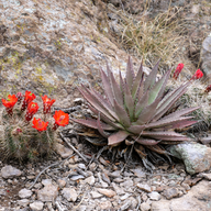
On the Hailstone Trail — nearly level with sweeping canyon views — we found one of the largest agave plants either of us had seen. We also noticed an agave that had grown its flower stalk and been removed, with the hollow center now filled with water — a natural basin. A tree with a hollow cavity a few feet off the ground, completely filled with rocks — we couldn't determine if the tree grew around them or if people placed them. The mystery of it was more satisfying than any explanation.
The Ed Riggs Trail climbs 400 feet back to Massai Point through a small canyon with large Douglas Firs and Ponderosa Pines. By the time we reached the top the light was nearly gone.
Total time at the monument: 2:00 PM to 6:20 PM.
That night we camped at a dispersed site on FR 42 across from FR 356 — one of the spots scouted on OnX before the trip. Simple dinner of burritos cooked in the dark — potatoes, sausage, black beans, cheese, and avocado. Small campfire after. Went to bed early.
Day Five — Ruins, a Pioneer Cemetery, and the Road Home
The final morning. We took FR 356 to check out some unnamed ruins found on OnX. Along the way we marked three promising dispersed camping locations and checked out two ruin sites.
The first had a small wood building with old bed springs covering the windows — inside, only a bin filled with rocks. Outside: a watering hole, corral, windmill filling a water tower, what appeared to be an old well. A new electrical panel confirmed the site is still in active use. The second site required crossing a dry wash — not advisable in a standard vehicle — and held the remains of barely visible rock walls in the grass. We look forward to exploring further up that canyon on a future visit.


Along the route to Chiricahua National Monument the previous day we had spotted something worth noting — a fenced-in headstone on the open landscape, belonging to Frank H. Hands (1862–1936) and Grace K. Hands (1876–1955). A private grave site in the open desert. The kind of quiet historical detail that stops you when you're paying attention.
We left the Coronado National Forest at 11:20 AM and headed home.
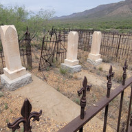
While heading home we came upon the Dos Cabezas Pioneer Cemetery — a quick browse of a site with many unmarked graves. A plaque acknowledges the unknown burials, the oldest dating to an infant from 1885. Walking through it you watch your step carefully, looking for snakes. The grass is tall and the ground is full of holes.


Final Notes
Five days. Two campgrounds. Two dispersed sites. One national monument. One rainstorm. One lightning experience. One river dip. Two long hikes. Lots of Turkeys seen.
The Chiricahua Mountains reward patience and attention — the more time you spend here the more it gives back. We came home with a list of things to return for: Crystal Cave, John Hands Waterfall, the upper canyon ruins on FR 356, Rustler Park under a dark sky, Barfoot Park on a clear day.
That's the sign of a good trip. You leave wanting more.
Visit our Bucket List for more details about these places:


Explore more Arizona camping locations and trip reports on the AZ Places Bucket List — firsthand guides to the places we've personally been. → Arizona Bucket List → Guided Camping Trips |


Comments