

AtoZ Bucket List
"Where have you been?"

Featured Video

AZ Places
This is our personal record of places explored — not a curated list from a travel site, but real trips, real roads, and real firsthand experience. Forests, deserts, lakes, rivers, hot springs, caves, peaks, ghost towns, ancient ruins, and more. Arizona, Utah, New Mexico, and beyond. Go find your next one.

Abandoned & Ghost Towns
Caves
Desert
Forest
Historical & Ancient Ruins
Hot Springs
Lakes & Rivers
National & State Parks
Peaks
Alamo Lake Wildlife Area


Alamo Lake Wildlife Area near Wenden, Arizona is a remote desert oasis where the Bill Williams River spreads into a 3,500-acre bass fishing lake surrounded by saguaro-covered mountains — with dispersed camping on secluded beaches and peninsulas, exceptional birdwatching year-round, and wild burros roaming the desert road in.
#Fishing, #Camping, #Lake, #Boating, #BLM, #ArizonaStateParks, #Hiking, #Recreation, #River, #Desert
Anasazi Inn & Painted Desert Project


The abandoned Anasazi Inn at Gray Mountain, Arizona has been transformed by the Painted Desert Project into a striking outdoor mural gallery — large-scale street art and wheat-paste photography covering the weathered walls of a forgotten roadside motel along Highway 89 on the Navajo Nation.
#Abandoned, #Desert, #Exploring, #Historical, #NavajoNation, #Photography
Anasazi Ridge Petroglyphs


The Temi' Po' Op' petroglyph site near Ivins, Utah offers a family-friendly 2.9-mile hike along the Santa Clara River to hundreds of ancient rock art panels, an Anasazi farmstead foundation, and sweeping views of the red rock canyon — one of the highest concentrations of petroglyphs in southern Utah.
#Ancient Ruins, #Petroglyphs, #Historical, #Hiking, #Desert
Apache Lake


Apache Lake, located in the Tonto National Forest, is a scenic reservoir offering both developed and dispersed camping options. Surrounded by steep canyon walls and accessible via the historic Apache Trail, it’s a hidden gem perfect for camping, boating, and outdoor adventures. The Burnt Corral Campground provides 76 campsites, and visitors can also enjoy secluded dispersed campsites with stunning views of the lake and desert landscape.
#Camping, #Boating, #TontoNationalForest, #Lake, #Recreation
Aztec Ruins National Monument


Aztec Ruins National Monument in New Mexico is home to a complex of ancient ruins built by the ancestral Puebloans over 900 years ago. As I walked through the park, I was struck by the impressive masonry of the structures and the rich history and culture they represent.
#Ancient Ruins, #Historical, #NationalMonument
Baker Hot Springs


We first visited Baker hot springs in 1995 and went on and off through out the years while I lived in SLC. We last visited while traveling through Utah in 2017, we camped near the springs at that time there was one other camper. This gentlemen served us pancakes in the morning and told us he had spotted a white llama that came down from the hill to drink from the water. During our visit the water was flowing well and appeared the tubs have been well maintained, due to lack of algae. We found an additional pool in the area that could be dipped in as well as the tubs. There was once some abandoned buildings in the area, they since I believe have been destroyed. I look forward to visiting Baker hot springs again.
#Camping, #HotSprings, #Desert
Bear Canyon Lake

Bear Canyon Lake is one of the most rewarding dispersed camping destinations on the Mogollon Rim — a beautiful, narrow, canyon-bound lake at 7,560 feet in the Apache-Sitgreaves National Forest, stocked with rainbow trout six times a year, surrounded by mixed conifer and aspen, and tucked far enough off the main road that solitude is almost always guaranteed.
#Camping, #Lake, #Forest, #Fishing
Bear Flat (FR 405)

Bear Flat is one of the Tonto National Forest's most rewarding and least-visited dispersed camping areas — easy forest road access through the pines near Payson, Arizona, with an old homestead site, a spring-fed canyon trail, wild blackberries and bear country solitude on FR 405 and 405A. Tonto Creek is a short drive away with access to a trail leading to the rugged Hellsgate Wilderness.
#Camping, #Fishing, #River, #Forest
Bear Springs | Sunny Park (FR 124)
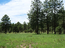
Discover the beauty of Arizona along Forest Road 124 in the Apache-Sitgreaves National Forest. This scenic destination features rugged forest terrain, towering ponderosa pines, and open meadows dotted with vibrant wild mushrooms. Visitors can also witness burn scars from the historic Rodeo-Chediski Fire, now blending with vibrant new growth—a powerful testament to nature's resilience. Wildlife you may encounter include wild horses, jackrabbits, deer, foxes, and squirrels.
#Camping, #Hiking, #Recreation, #MogollonRim, #ApacheSitgreaves, #Forest
Black Canyon (FR 300)

Black Canyon Rim Road (FR 300) winds through the cool, pine-covered high country of Arizona’s Mogollon Rim region, offering a peaceful escape surrounded by towering ponderosa forests. Located just minutes from Black Canyon Lake and only 12 miles from Willow Springs Lake, this area is ideal for dispersed camping, trout fishing, hiking the historic General Crook Trail, and visiting landmarks like the Pleasant Valley War gravesite. Frequent wildlife sightings—such as wild horses, elk, and bears—add to the adventure in this quiet, off-the-beaten-path destination.
#Camping, #Fishing, #Hiking, #Lake, #MogollonRim
Black Canyon Lake
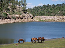
Black Canyon Lake is a scenic 78-acre trout fishing lake on the Mogollon Rim in the Apache-Sitgreaves National Forest — a quiet alternative to the more visited Rim Lakes, with forested shoreline, electric motor boating, and wild horses known to stop at the water's edge.
#ApacheSitgreaves, #Boating, #Exploring, #Fishing, #Forest, #Hiking, #Lake, #MogollonRim
Black River (Fork Confluence)

The confluence of the East Fork and West Fork Black River in the Apache-Sitgreaves National Forest is one of Arizona's most rewarding dispersed camping destinations — reached via the short but rough Home Creek Road (FR 8750), with trout fishing, a spillway swimming hole, and genuine high-country solitude at nearly 7,500 feet.
#Camping, #Fishing, #Forest, #Hiking, #River, #ApacheSitgreaves, #Recreation, #Wildlife

Arizona
Abandoned & Ghost Towns
Caves
Desert
Forest
Historical & Ancient Ruins
Hot Springs
Lakes & Rivers
National & State Parks
Peaks