

AtoZ Bucket List
"Where have you been?"
Abandoned & Ghost Towns
Caves
Desert
Forest
Historical & Ancient Ruins
Hot Springs
Lakes & Rivers
National & State Parks
Peaks

Peaks
From volcanic cinder cones to granite summits, Arizona's peaks offer some of the most rewarding views in the Southwest. You don't always have to hike to the top — sometimes the drive up is enough. These are the high points we've stood on and the ones still on our list

McFadden Peak


McFadden Peak, the site of one of two fire lookouts in the Sierra Ancha, offers continuous views of the surrounding areas. This peak was named for William McFadden, who started the Circle Ranch on McFadden Creek. McFadden had been part of a vigilante group during the Pleasant Valley War, and later settled in the Sierra Anchas to get away from the feud.
#Hiking, #Forest, #Camping
Mount Graham (Pinaleño Mountains)
Mount Graham — the 10,720-foot summit of the Pinaleño Mountains — is Arizona's tallest sky island range in the Coronado National Forest near Safford, offering dramatic elevation changes, ancient mixed-conifer forest, Riggs Flat Lake, and some of the most diverse wildlife in North America including the endangered Mount Graham red squirrel.
#Boating, #Camping, #Exploring, #Fishing, #Forest, #Hiking, #Lake, #Photography, #Wildlife
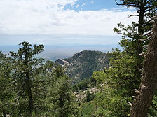
Mt Lemmon

Mount Lemmon is the crown of the Santa Catalina Sky Island — a 9,159-foot escape rising from Tucson's desert floor through six life zones to pine forest, dispersed camping, hiking, and the southernmost ski area in the United States, all accessible via the 27-mile Catalina Highway Scenic Byway.
#Fishing, #Hiking, #Camping, #Lake, #Forest
Picacho Peak State Park


Picacho Peak State Park, located along Arizona's I-10 corridor, is a stunning desert destination known for its striking peak, hiking trails, and rich history. A favorite for outdoor enthusiasts, the park offers camping, wildlife watching, and breathtaking desert views.
#Camping, #Hiking, #ArizonaStateParks, #SonoranDesert, #Desert, #Historical
Pinal Mountains

The Pinal Mountains rise to 7,848 feet just south of Globe, Arizona — a sky island of ponderosa pine and white fir tucked inside the Tonto National Forest, offering cool summer camping, eight hiking trails, sweeping views from the lookout tower and some of the most surprising wildlife encounters in central Arizona.
#Forest, #Camping, #Recreation, #Hiking, #Historical, #Wildlife, #Exploring, #Photography
See a tent?

Place has camping
or close by.
Abandoned & Ghost Towns
Caves
Desert
Forest
Historical & Ancient Ruins
Hot Springs
Lakes & Rivers
National & State Parks
Peaks