

AtoZ Bucket List
"Where have you been?"
Abandoned & Ghost Towns
Caves
Desert
Forest
Historical & Ancient Ruins
Hot Springs
Lakes & Rivers
National & State Parks
Peaks

Forest
Arizona's forests surprise people who only know the desert side of the state. The Apache-Sitgreaves, Coconino, Prescott, and Tonto National Forests cover millions of acres of tall pines, mountain meadows, and canyon country at elevation. This is where we do most of our camping — and where AZ Places guided trips are based.

Bear Canyon Lake


Bear Canyon Lake is one place we go most often. There are plenty of places to setup camp and lots to explore. We have never had a issue finding a spot to camp, at times can barely hear anyone around. We pass all the nearest sites near the lake and go past the powerlines where there are plenty of sites spread out. From there it is a bit of a hike to the lake, or short drive. Depending upon the season you can hear elk and coyotes in the area.
#Camping, #Lake, #Forest, #Fishing
Bear Flat (FR 405)

Bear Flat is one of the Tonto National Forest's most rewarding and least-visited dispersed camping areas — easy forest road access through the pines near Payson, Arizona, with an old homestead site, a spring-fed canyon trail, wild blackberries and bear country solitude on FR 405 and 405A. Tonto Creek is a short drive away with access to a trail leading to the rugged Hellsgate Wilderness.
#Camping, #Fishing, #River, #Forest
Bear Springs | Sunny Park (FR 124)


Discover the beauty of Arizona along Forest Road 124 in the Apache-Sitgreaves National Forest. This scenic destination features rugged forest terrain, towering ponderosa pines, and open meadows dotted with vibrant wild mushrooms. Visitors can also witness burn scars from the historic Rodeo-Chediski Fire, now blending with vibrant new growth—a powerful testament to nature's resilience. Wildlife you may encounter include wild horses, jackrabbits, deer, foxes, and squirrels.
#Camping, #Hiking, #Recreation, #MogollonRim, #ApacheSitgreaves, #Forest
Black Canyon (FR 300)

Black Canyon Rim Road (FR 300) winds through the cool, pine-covered high country of Arizona’s Mogollon Rim region, offering a peaceful escape surrounded by towering ponderosa forests. Located just minutes from Black Canyon Lake and only 12 miles from Willow Springs Lake, this area is ideal for dispersed camping, trout fishing, hiking the historic General Crook Trail, and visiting landmarks like the Pleasant Valley War gravesite. Frequent wildlife sightings—such as wild horses, elk, and bears—add to the adventure in this quiet, off-the-beaten-path destination.
#Camping, #Fishing, #Hiking, #Lake, #MogollonRim
Blue Ridge Reservoir

Camping near C.C. Cragin Reservoir offers a unique escape into nature, where you can enjoy peaceful solitude surrounded by rugged canyon walls, serene waters ideal for kayaking, and the thrill of fishing for rainbow trout, all while being immersed in the diverse wildlife and scenic beauty of the area.
#Boating, #Camping, #Fishing, #Forest, #CoconinoNationalForest
Bradshaw City Ghost Town


Explore the historic ruins of Bradshaw City, a former gold-mining boomtown established in 1863 in Yavapai County, Arizona. Once home to nearly 5,000 residents, today it offers visitors a fascinating glimpse into Arizona's mining past, surrounded by beautiful forested landscapes.
#Camping, #GhostTown, #Forest
Chevelon Canyon Lake

Chevelon Canyon Lake, nestled on the Mogollon Rim in northern Arizona, is a serene, hidden gem offering fishing, hiking, and camping. Accessible via a challenging hike, this narrow reservoir is surrounded by rugged canyon views, perfect for nature lovers seeking adventure.
#Camping, #Fishing, #Forest, #Hiking, #Lake, #Recreation, #Boating, #MogollonRim
Happy Jack (FR 81)

Happy Jack, located in the Mogollon Rim Ranger District of the Coconino National Forest, offers a peaceful escape for dispersed camping. With its cooler summer temperatures, towering pines, and diverse wildlife, it’s a perfect destination for outdoor exploration and relaxation.
#Camping, #CoconinoNationalForest, #Forest, #Hiking, #Recreation
Moqui (FR 95)

FR 95 is a 30-mile forest road corridor through the Coconino National Forest below the Mogollon Rim — offering some of the best dispersed camping in Arizona, with nearby access to East Clear Creek, the historic Moqui Lookout fire tower, Blue Ridge Reservoir, water play in Barbershop Canyon, and miles of ponderosa pine backcountry to explore.
#Camping, #Hiking, #Lake, #MogollonRim, #Forest, #Recreation
Mount Graham (Pinaleño Mountains)
Mount Graham — the 10,720-foot summit of the Pinaleño Mountains — is Arizona's tallest sky island range in the Coronado National Forest near Safford, offering dramatic elevation changes, ancient mixed-conifer forest, Riggs Flat Lake, and some of the most diverse wildlife in North America including the endangered Mount Graham red squirrel.
#Boating, #Camping, #Exploring, #Fishing, #Forest, #Hiking, #Lake, #Photography, #Wildlife
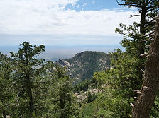
Mt Lemmon

Mount Lemmon is the crown of the Santa Catalina Sky Island — a 9,159-foot escape rising from Tucson's desert floor through six life zones to pine forest, dispersed camping, hiking, and the southernmost ski area in the United States, all accessible via the 27-mile Catalina Highway Scenic Byway.
#Fishing, #Hiking, #Camping, #Lake, #Forest
Old Rim Road (FR 171)

Escape into Arizona’s rugged high country along FR 171 and Young Road, where peaceful pine forests, dispersed campsites, and rim-edge views invite backcountry adventure. Located within easy reach of Willow Springs Lake for fishing and picnics, this quieter alternative to the main Rim Road is perfect for wildlife watching, off-grid camping, and exploring the cool, scenic landscapes of the Mogollon Rim region.
#Camping, #Forest, #Hiking, #Recreation, #MogollonRim, #ApacheSitgreaves
Pinal Mountains

The Pinal Mountains rise to 7,848 feet just south of Globe, Arizona — a sky island of ponderosa pine and white fir tucked inside the Tonto National Forest, offering cool summer camping, eight hiking trails, sweeping views from the lookout tower and some of the most surprising wildlife encounters in central Arizona.
#Forest, #Camping, #Recreation, #Hiking, #Historical, #Wildlife, #Exploring, #Photography
West Fork Campground

Discover West Fork Campground in the scenic Black River area of the Apache-Sitgreaves National Forest. At 7,740 feet elevation, this peaceful, undeveloped site offers dappled shade beneath towering pines, abundant wildlife, and opportunities for river play. Open from May to October, this free camping spot invites adventurers seeking a rustic, nature-immersed experience.
#Camping, #Fishing, #River, #Forest
See a tent?

Place has camping
or close by.
Abandoned & Ghost Towns
Caves
Desert
Forest
Historical & Ancient Ruins
Hot Springs
Lakes & Rivers
National & State Parks
Peaks