
Sand Island Petroglyphs
AtoZ Places Bucket Location


Abandoned & Ghost Towns

Ancient Ruins

Caves

Desert

Forest

Historical

Hot Springs

Lakes & Rivers

National & State Parks

Peaks


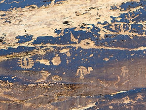


Sand Island Petroglyphs near Bluff, Utah preserves over 100 yards of continuous rock art panel on the banks of the San Juan River — spanning 2,500 to 8,000 years of human history from Archaic hunters to Ancestral Puebloans, Ute, and Navajo peoples, including five Kokopelli figures, San Juan Anthropomorphs, and some of the most accessible ancient rock art in the Bears Ears National Monument region.
Desert
Ancient Ruins

Exploring

Camping

Dogs should remain on leash

Free entry — no entrance fee
Toilets: Vault toilets available.
Water: No potable water; pack your own supply.
More Info
Plants Foraged
Nearby Locations
Valley of the Gods

Fish Creek Canyon Wilderness (The Twist)
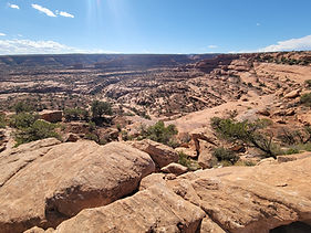
Muley Point

Sand Island Petroglyphs
Three miles west of Bluff, Utah on the south bank of the San Juan River, a sandstone cliff face holds one of the most remarkable and accessible concentrations of ancient rock art in the American Southwest. Sand Island Petroglyphs stretches for more than 100 yards — a continuous panel of figures, symbols, and images representing thousands of years of human presence along this river corridor.
We made a short stop here on September 8, 2025 — part of our northern Arizona and southern Utah loop that included Painted Desert Project, Navajo National Monument, Monument Valley, Valley of the Gods, Moki Dugway, Muley Point, and Fish Creek Canyon Wilderness. The San Juan River country between Bluff and Mexican Hat is one of the most archaeologically dense landscapes in North America, and Sand Island is the most accessible entry point into that world — a short walk from a paved road leads to a panel that spans the entire human history of the Four Corners region.
We enjoyed seeing the accumulation of images spanning the full length of the panel. The panel held a remarkable variety — human figures, animals, geometric symbols, Kokopelli figures, and the inevitable graffiti left by those who came later and couldn't resist adding their own mark to something that had endured for thousands of years. Standing in front of a continuous stretch of rock art this long, created by people across dozens of generations and multiple cultures, is one of those experiences that resets your sense of time.
The Panel — Thousands of Years of History on One Wall
Carbon dating of a sandal found in the general area showed the site was likely occupied as early as 6,500 BC — and there are petroglyphs on the panel that may be that old. The main west panel spans from the earliest Archaic period through the Pueblo III era (approximately 800–2,500 years ago) and into the historic period with Ute and Navajo additions in more recent centuries. Every group that came through this part of the San Juan River corridor left a mark here — the sheer accumulation of images across cultures and centuries suggests this location held special significance as a gathering place along the river.
The panel is on the National Register of Historic Places and is now part of Bears Ears National Monument.
What to Look For
The images on the panel span multiple artistic traditions and time periods — learning to read the differences between them is part of what makes a careful visit so rewarding.
Glen Canyon Linear figures — among the oldest images on the panel, found on the left side as you face it. Tall, angular, abstract figures from the Archaic period. These are some of the oldest rock art in the region.
San Juan Anthropomorphs — large, broad-shouldered human figures with splayed hands, unique to the San Juan River area. Distinctive and immediately recognizable once you know what you're looking at.
Kokopelli — the flute-playing figure found throughout Southwestern rock art. There are five Kokopellis on this panel. Finding all five is a worthwhile exercise in close looking.
Animal figures — sheep, deer, dogs, birds, and horses (the presence of horses indicates post-Spanish contact additions from Ute or Navajo artists after approximately 1600 CE).
Human figures — dancers, hunters, figures with headdresses, and figures that defy easy interpretation.
Twin heads and twin lobes — connected to stories of twins found in multiple Native creation traditions. The Bluff area has notable twin rock formations on both sides of the river — was this connection intentional?
19th and 20th century inscriptions — pioneer and rancher graffiti mixed into the panel, a frustrating but historically documented feature of accessible rock art sites throughout the Southwest.
The panel is protected by a fence — you can view and photograph freely but cannot touch. Do not touch the petroglyphs under any circumstances. The oils from human hands accelerate the deterioration of rock art that has survived for thousands of years.
The East Trail — Additional Panels
A one-mile round trip trail on the east side of the campground visits several additional rock art sites — smaller than the main west panel but worth exploring for the variety of images and the river views along the route. A side canyon near the end of the trail holds another small panel. Horse petroglyphs appear near the end of the east trail. One panel on the river bend is difficult to photograph due to the river coming up against the cliff directly below it — worth seeing regardless.
Sand Island Campground — The Base
Sand Island Recreation Area includes a campground of approximately 23–25 sites on the banks of the San Juan River — first-come first-served, no advance reservations. Camping fee approximately $15/night, paid on-site. Cash or personal check only — no electronic payments. Vault toilets available. Water is seasonal — bring your own and do not depend on it being available. The campground is also the primary put-in for the 102-mile San Juan River float between Montezuma Creek and Clay Hills Crossing — one of the premier river trips in the Southwest.
Bears Ears National Monument
Sand Island is part of Bears Ears National Monument — the 1.36-million-acre monument designated in 2016 and restored to full boundaries in 2021, encompassing some of the most archaeologically significant land in North America. The San Juan River corridor from Bluff through Mexican Hat and beyond is the southern boundary of the monument's canyon country. Sand Island is the most accessible point of entry into that landscape for most visitors.
Ranger District
BLM Monticello Field Office
365 N. Main Street, Monticello, UT 84535
(435) 587-1500
More Information
Campground: ~$15/night — cash or personal check only, no electronic payments
No advance reservations — first-come first-served
Do not touch the petroglyphs — oils from hands accelerate deterioration
East trail: 1-mile round trip to additional panels — begins east side of campground
Sand Island is the primary put-in for San Juan River floats — commercial and private trips
#SandIslandPetroglyphs #BearsEarsNationalMonument #BluffUtah #SanJuanRiver #AncestralPuebloans #RockArt #Petroglyphs #Kokopelli #UtahRockArt #AZPlaces #FourCorners #SanJuanCounty #AncientHistory #BLMUtah #SouthwestUSA
Campground

Utah
796J+MC Bluff, UT

San Juan County
37°15'42.0"N 109°37'07.3"W
Elevation: 4,300 feet
Directions
From Bluff, UT: Head west on US-191 approximately 3 miles from downtown Bluff. Watch for the signed Sand Island Recreation Area turnoff on the left (south) side of the highway. Follow the road down to the campground and parking area. The petroglyph panel is immediately visible on the cliff face above the campground.
From Mexican Hat, UT: Head north on US-163 to the junction with US-191 near Bluff. Turn right (east) on US-191 and continue approximately 3 miles to the Sand Island turnoff on the right.


Best Seasons & Temperatures
Spring and fall are ideal — mild temperatures and low crowds. The petroglyph panel is accessible year-round and equally rewarding in any season. Summer heat in the canyon country below Bluff can be extreme — go early morning. Winter visits are quiet and the panel is unchanged regardless of weather. The campground is open year-round but water is seasonal — always bring your own. The San Juan River float season runs primarily spring through early summer.
Sand Island Petroglyphs San Juan River Bluff Utah Bears Ears National Monument Ancestral Puebloan rock art
September 8, 2025