

AtoZ Bucket List
"Where have you been?"

Abandoned & Ghost Towns

Ancient Ruins

Caves

Desert

Forest

Historical

Hot Springs

Lakes & Rivers

National & State Parks

Peaks

Ancient Ruins
Arizona and the greater Southwest hold some of the most significant prehistoric sites in North America — cliff dwellings, great houses, hilltop pueblos, petroglyphs, and pottery fields left by the Hohokam, Sinagua, Ancestral Puebloans, and Salado peoples. These are not reconstructions or replicas. They are the real thing, still standing in the same desert and canyon country where they were built centuries ago. We believe in seeing them firsthand.

Anasazi Ridge Petroglyphs


The Temi' Po' Op' petroglyph site near Ivins, Utah offers a family-friendly 2.9-mile hike along the Santa Clara River to hundreds of ancient rock art panels, an Anasazi farmstead foundation, and sweeping views of the red rock canyon — one of the highest concentrations of petroglyphs in southern Utah.
#Ancient Ruins, #Petroglyphs, #Historical, #Hiking, #Desert
Aztec Ruins National Monument


Aztec Ruins National Monument in Aztec, New Mexico preserves one of the best-preserved Ancestral Puebloan great house complexes in the American Southwest — a UNESCO World Heritage Site featuring the West Ruin's 400+ interconnected rooms, original wooden ceiling beams, and the largest reconstructed Great Kiva in North America, walkable on a self-guided tour through rooms built in the 1100s.
#Ancient Ruins, #Historical, #NationalMonument
Casa Grande Ruins National Monument
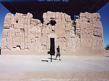

Casa Grande Ruins National Monument in Coolidge, Arizona preserves the largest known prehistoric structure in North America — a four-story Hohokam adobe Great House built around 1350 CE, protected by a massive steel canopy, designated as America's first archaeological reserve in 1892, and surrounded by the remnants of a sophisticated farming civilization that irrigated the Sonoran Desert for over a thousand years.
#Ancient Ruins, #Desert, #Exploring, #NationalMonument, #Photography
Chaco Culture National Historical Park


Chaco Culture National Historical Park in northwestern New Mexico is one of the most significant and least visited archaeological sites in North America — a UNESCO World Heritage Site preserving thirteen major Ancestral Puebloan great houses built between 850 and 1250 CE in a remote canyon that served as the ceremonial, economic, and astronomical center of a civilization spanning 50,000 square miles of the Colorado Plateau.
#Ancient Ruins, #Camping, #Hiking, #Historical, #Petroglyphs, #NationalPark
Chiricahua National Monument

Chiricahua National Monument in southeastern Arizona preserves one of the most spectacular volcanic rock landscapes in North America — 27 million years of erosion have carved towering rhyolite pinnacles, balanced rocks, and soaring spires from the Chiricahua Mountains, explored via 17 miles of hiking trails and an 8-mile scenic drive to Massai Point.
#Ancient Ruins, #Camping, #Hiking, #Historical, #NationalMonument, #Wildlife, #Photography, #Exploring, #Desert
Fish Creek Canyon Wilderness (The Twist)

Fish Creek Canyon Wilderness Study Area on Cedar Mesa in San Juan County, Utah is one of the most remote and rewarding backcountry destinations in the Bears Ears region — deep canyons reaching 700 feet, natural arches, Ancestral Puebloan ruins, and the historic Emigrant Trail route followed by Mormon pioneers in 1879, accessed via the rugged Snow Flat Road (BLM 237) through some of the most spectacular canyon country in the Southwest.
#Ancient Ruins, #BLM, #Camping, #Desert, #Exploring, #Historical, #Hiking, #Petroglyphs, #Photography, #StarGazing, #Wildlife, #Views
Homolovi State Park

Homolovi State Park near Winslow, Arizona preserves over 300 ancestral Hopi archaeological sites from the 13th and 14th centuries — including the partially excavated pueblos of Homolovi I and II, pottery shards scattered across the desert floor, petroglyphs, and an exceptional visitor center museum telling the story of the Hisat'sinom people who paused here on their great migration north.
#Ancient Ruins, #ArizonaStateParks, #Desert, #Exploring, #Hiking
Montezuma Castle National Monument

Montezuma Castle National Monument near Camp Verde preserves one of the best-preserved prehistoric cliff dwellings in North America — a five-story, 20-room Sinagua apartment complex notched 90 feet up a limestone cliff above Beaver Creek, designated in 1906 as one of America's first four national monuments and still as remarkable today as when Theodore Roosevelt first protected it.
#Ancient Ruins, #Desert, #Exploring, #Hiking, #Historical, #NationalMonument, #Photography, #Wildlife
Montezuma Well

Montezuma Well near Rimrock, Arizona is one of the most quietly astonishing natural features in the American Southwest — a 368-foot-wide, 55-foot-deep limestone sinkhole discharging 1.5 million gallons of spring water daily, home to five species found nowhere else on Earth, surrounded by 900-year-old Sinagua cliff dwellings and an irrigation canal still carrying water today.
#Ancient Ruins, #Desert, #Exploring, #Historical, #NationalMonument, #Wildlife, #Hiking
Navajo Moenave Dinosaur Tracks

The Navajo Moenave Dinosaur Tracks near Tuba City, Arizona preserve hundreds of authentic Early Jurassic footprints embedded in 200-million-year-old sandstone — walked among in the open desert with Navajo guides from the community of Moenave, no glass cases, no barriers, no crowds. Just the tracks and the landscape where they were made.
#Desert, #Exploring, #NavajoNation
Navajo National Monument

Navajo National Monument in northern Arizona preserves three of the most intact Ancestral Puebloan cliff dwellings in the Southwest — Betatakin, Keet Seel, and Inscription House — set within the dramatic Tsegi Canyon system on the Navajo Nation, with free entry, free camping, and ranger-led tours to dwellings last occupied around 1300 AD.
#Ancient Ruins, #Desert, #Exploring, #Historical, #Hiking, #NationalMonument, #NavajoNation, #Petroglyphs, #Photography, #Wildlife
Palatki Heritage Site

Palatki Heritage Site is one of the largest and best-preserved Sinagua cliff dwelling complexes near Sedona, Arizona — featuring ancient rock art, pictographs up to 6,000 years old, and guided tours through red sandstone alcoves in the Coconino National Forest.
#Ancient Ruins, #Petroglyphs, #CoconinoNationalForest
Saddle Mountain


Saddle Mountain near Tonopah, Arizona is one of the Phoenix area's most rewarding BLM dispersed camping destinations — a volcanic mountain range at 2,600 feet in the western Sonoran Desert where rockhounds find chalcedony, fire agate, and quartz crystals on the desert floor, ancient petroglyphs mark the volcanic slopes, spectacular sunsets paint the sky, and javelina, jackrabbit, and ocotillo in bloom complete a classic desert spring experience within an hour of the Valley.
#Hiking, #SonoranDesert, #Camping, #Recreation, #Petroglyphs, #RockHounding
Sand Island Petroglyphs

Sand Island Petroglyphs near Bluff, Utah preserves over 100 yards of continuous rock art panel on the banks of the San Juan River — spanning 2,500 to 8,000 years of human history from Archaic hunters to Ancestral Puebloans, Ute, and Navajo peoples, including five Kokopelli figures, San Juan Anthropomorphs, and some of the most accessible ancient rock art in the Bears Ears National Monument region.
#Petroglyphs, #BLM, #Camping, #Desert, #Exploring, #Historical, #Photography
Sears Kay Ruins

Sears Kay Ruins is an ancient Hohokam fortification in the Tonto National Forest near Carefree, Arizona — listed on the National Register of Historic Places and accessible via a short self-guided loop trail with sweeping desert views.
#Ancient Ruins, #Exploring, #Hiking, #Historical, #TontoNationalForest
Shoofly Village Ruins

Shoofly Village Ruins near Payson, Arizona is one of the most accessible ancient archaeological sites on the Mogollon Rim — a 4-acre prehistoric compound with 80+ rooms, a surrounding stone wall, and interpretive signs that bring a 1,000-year-old community back to life.
#Ancient Ruins, #Exploring, #Desert, #Hiking, #Historical, #TontoNationalForest
Tonto National Monument

The Salado Phenomena, 700 years ago, blended ideas of neighboring Native American cultures to emerge a unique and vibrant society. Tonto National Monument showcases two Salado-style cliff dwellings. Colorful pottery, woven cotton cloth, and other artifacts tell a story of people living and using resources from the northern Sonoran Desert from 1250 to 1450 CE.
#Hiking, #NationalMonument
Tuzigoot National Monument

Tuzigoot National Monument near Clarkdale, Arizona preserves a 110-room Sinagua hilltop pueblo built between 1000 and 1400 CE — one of the best-preserved prehistoric villages in the American Southwest, with sweeping views of the Verde Valley, a museum of 3,000+ artifacts, and a short self-guided loop trail through stone rooms occupied by 250 people for nearly 400 years.
#Ancient Ruins, #Desert, #Hiking, #NationalMonument, #Photography
Valley of the Gods

Valley of the Gods near Mexican Hat, Utah is the lesser-known cousin of Monument Valley — a 17-mile BLM loop road through isolated sandstone buttes, mesas, and spires carved from 250-million-year-old Cedar Mesa sandstone, with free dispersed camping on the valley floor, no fees, and formations named Seven Sailors, Castle Butte, Rooster Butte, Setting Hen, and more.
#BLM, #Camping, #Desert, #Exploring, #Hiking, #Historical, #Photography, #StarGazing, #Wildlife, #Views
Walnut Canyon National Monument

Walnut Canyon National Monument just east of Flagstaff preserves 25 remarkably intact Sinagua cliff dwelling rooms tucked into the limestone ledges of a 350-foot deep canyon — occupied from approximately 1100 to 1250 CE, explored on two short trails through a canyon ecosystem of remarkable botanical diversity where desert and mountain plant communities converge in a single narrow gorge.
#Ancient Ruins, #Historical, #Hiking, #NationalMonument
Wupatki National Monument

Wupatki National Monument north of Flagstaff preserves over 2,700 ancient sites across 55 square miles of painted desert — centered on the 104-room Wupatki Pueblo, the northernmost ball court ever discovered, a geological blowhole that breathes with the earth's pressure, and five accessible pueblos built from the distinctive red Moenkopi sandstone of the Colorado Plateau.
#Ancient Ruins, #Desert, #Exploring, #Hiking, #Historical, #NationalMonument, #Photography
See a tent?

Place has camping
or close by.

Abandoned & Ghost Towns

Ancient Ruins

Caves

Desert

Forest

Historical

Hot Springs

Lakes & Rivers

National & State Parks

Peaks