

AtoZ Bucket List
"Where have you been?"

Featured Video

AZ Places
This is our personal record of places explored — not a curated list from a travel site, but real trips, real roads, and real firsthand experience. Forests, deserts, lakes, rivers, hot springs, caves, peaks, ghost towns, ancient ruins, and more. Arizona, Utah, New Mexico, and beyond. Go find your next one.

Abandoned & Ghost Towns
Caves
Desert
Forest
Historical & Ancient Ruins
Hot Springs
Lakes & Rivers
National & State Parks
Peaks
Bradshaw City Ghost Town


Explore the historic ruins of Bradshaw City, a former gold-mining boomtown established in 1863 in Yavapai County, Arizona. Once home to nearly 5,000 residents, today it offers visitors a fascinating glimpse into Arizona's mining past, surrounded by beautiful forested landscapes.
#Camping, #GhostTown, #Forest
C.C. Cragin Reservoir


Camping near C.C. Cragin Reservoir offers a unique escape into nature, where you can enjoy peaceful solitude surrounded by rugged canyon walls, serene waters ideal for kayaking, and the thrill of fishing for rainbow trout, all while being immersed in the diverse wildlife and scenic beauty of the area.
#Boating, #Camping, #Fishing, #Forest, #CoconinoNationalForest
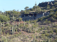
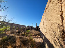
Casa Grande Domes


The Domes of Casa Grande was four massive structures located in Casa Grande, Arizona, that were built to facilitate the manufacturing of computers in the late 1970s and early 1980s. However, the project was never completed, leaving behind only a few foundations that were started and left to molder. One of the buildings is shaped like a flying saucer, and the other three resemble spheres joined together. Despite their abandoned state, the Domes remain a popular destination for urban explorers and photographers, drawing visitors to their otherworldly appearance.
#Abandoned, #Desert
Chaco Culture National Historical Park
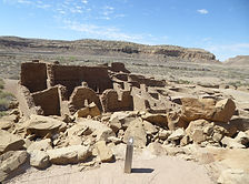

This Chaco Canyon Valley, high-desert landscape has long winters, short growing seasons, and marginal rainfall. Yet, it became the center of a thriving culture a thousand years ago. It was an unlikely place for a major center of ancestral Puebloan culture to take root and flourish. The grand scale of its architecture is monumental, making it a center hub for far-reaching commerce with complex community life and high levels of social organization, creating a cultural vision unlike any other seen before or since. That began in the mid 800s and lasted more than 300 years. Their descendants are the modern Southwest Indians. Many Southwest Indian people look upon Chaco as an important stop along their clans' sacred migration paths-a spiritual place to be honored and respected.
#Ancient Ruins, #Camping, #Hiking, #Historical, #Petroglyphs, #NationalPark
Chevelon Canyon Lake
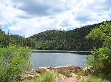
Chevelon Canyon Lake, nestled on the Mogollon Rim in northern Arizona, is a serene, hidden gem offering fishing, hiking, and camping. Accessible via a challenging hike, this narrow reservoir is surrounded by rugged canyon views, perfect for nature lovers seeking adventure.
#Camping, #Fishing, #Forest, #Hiking, #Lake, #Recreation, #Boating, #MogollonRim
Chiricahua Mountains

Cave Creek Canyon in the Chiricahua Mountains near Portal, Arizona is one of the most biologically diverse canyons in North America — a birding mecca with 370+ species, spectacular rhyolite cliffs, year-round flowing streams, multiple campgrounds, waterfalls, and dispersed camping across one of Arizona's most rewarding sky island ranges.
#Camping, #Exploring, #Forest, #Hiking, #Historical, #Recreation, #River, #Wildlife, #Photography
Chiricahua National Monument

Chiricahua National Monument in southeastern Arizona preserves one of the most spectacular volcanic rock landscapes in North America — 27 million years of erosion have carved towering rhyolite pinnacles, balanced rocks, and soaring spires from the Chiricahua Mountains, explored via 17 miles of hiking trails and an 8-mile scenic drive to Massai Point.
#Ancient Ruins, #Camping, #Hiking, #Historical, #NationalMonument, #Wildlife, #Photography, #Exploring, #Desert
Christopher Creek Campground

Christopher Creek Campground is a classic Mogollon Rim escape tucked along the banks of a spring-fed creek in the Tonto National Forest — ponderosa pines, flowing water, stocked trout, and cool mountain air just 90 minutes from Phoenix at 5,640 feet elevation.
#TontoNationalForest, #Wildlife, #River, #Recreation, #Photography, #Hiking, #Forest, #Exploring, #Camping
Colossal Cave Mountain Park
Colossal Cave Mountain Park has cave tours, hiking & biking, trail rides, camping & picnicking, terrace Café & gift shop. The campsites are tucked among the saguaro cacti and mesquite trees in Posta Quemada canyon. These grounds consist of two large areas, El Bosquecito and La Selvilla, both have water and restrooms. Additionally there are a number of smaller areas totaling 30 individual sites. Camping is first-come, first-served. This is primitive camping. No electricity or RV hook-ups available. are located in El Bosquecito and La Selvilla.
#Camping, #Cave, #Historical, #Hiking, #Recreation, #Desert
Courtland Ghost Town

Nestled in an arid landscape, Courtland, born from early 1900s mining fervor, whispers tales of a once-thriving community. A fading jail, a collapsing store, and silent foundations stand as echoes of its past. The hills, marked by mines, caution visitors of the hidden hazards within the remnants of Courtland's mining legacy.
#GhostTown, #Historical, #Exploring, #Desert, #Wildlife
Gleeson Ghost Town
Gleeson Ghost Town is one of southeastern Arizona's most atmospheric abandoned mining communities — featuring the ruins of a hospital, saloon, school foundation, and a restored 1910 concrete jail turned museum, set against the dramatic backdrop of the Dragoon Mountains.
#GhostTown, #Historical, #Exploring, #Wildlife, #Desert
Happy Jack (FR 81)
Happy Jack, located in the Mogollon Rim Ranger District of the Coconino National Forest, offers a peaceful escape for dispersed camping. With its cooler summer temperatures, towering pines, and diverse wildlife, it’s a perfect destination for outdoor exploration and relaxation.
#Camping, #CoconinoNationalForest, #Forest, #Hiking, #Recreation

Arizona
Abandoned & Ghost Towns
Caves
Desert
Forest
Historical & Ancient Ruins
Hot Springs
Lakes & Rivers
National & State Parks
Peaks