

AtoZ Bucket List
"Where have you been?"

Featured Video

AZ Places
This is our personal record of places explored — not a curated list from a travel site, but real trips, real roads, and real firsthand experience. Forests, deserts, lakes, rivers, hot springs, caves, peaks, ghost towns, ancient ruins, and more. Arizona, Utah, New Mexico, and beyond. Go find your next one.


Abandoned & Ghost Towns

Ancient Ruins

Caves

Desert

Forest

Historical

Hot Springs

Lakes & Rivers

National & State Parks

Peaks
Sears Kay Ruins


Sears Kay Ruins is an ancient Hohokam fortification in the Tonto National Forest near Carefree, Arizona — listed on the National Register of Historic Places and accessible via a short self-guided loop trail with sweeping desert views.
#Ancient Ruins, #Exploring, #Hiking, #Historical, #TontoNationalForest
Sheep Bridge Hot Springs


Sheep Bridge Hot Springs is one of Arizona's most remote natural soaking spots — a 99°F geothermal spring on the banks of the Verde River in the Tonto National Forest, reached only by a rugged 4x4 drive through Bloody Basin or a long backcountry hike.
#Camping, #Desert, #Exploring, #Fishing, #Hiking, #HotSprings, #OffRoad, #River, #TontoNationalForest, #Wildlife
Shoofly Village Ruins

Shoofly Village Ruins near Payson, Arizona is one of the most accessible ancient archaeological sites on the Mogollon Rim — a 4-acre prehistoric compound with 80+ rooms, a surrounding stone wall, and interpretive signs that bring a 1,000-year-old community back to life.
#Ancient Ruins, #Exploring, #Desert, #Hiking, #Historical, #TontoNationalForest
Silver Bell Cemetery


Silver Bell Cemetery is a historic frontier graveyard tucked inside the Ironwood Forest National Monument near Marana, Arizona — the last visible remnant of the original Silverbell mining community that boomed and went bust in the early 1900s.
#Abandoned, #Historical, #Exploring, #BLM
Silver Reef Ghost Town
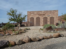

Silver Reef Ghost Town near Leeds, Utah is one of the American West's most geologically unusual mining towns — the only place in history where silver was found in sandstone rather than the quartz or granite that every mining expert of the era insisted was required. Founded in 1875 and abandoned by 1891, the ruins of its stone buildings, original jail, Wells Fargo Express office, mill remains, and pioneer cemetery survive in the red rock landscape of Washington County.
#GhostTown, #Abandoned, #Historical, #Camping, #Recreation, #Desert
Slide Rock State Park

Slide Rock State Park in Oak Creek Canyon north of Sedona is one of Arizona's most beloved natural attractions — an 80-foot natural sandstone water slide worn slick by Oak Creek, a historic 1912 apple orchard, wading pools, hiking trails, and canyon views that have drawn visitors from around the world since Frank Pendley built his homestead here more than a century ago.
#ArizonaStateParks, #River, #Recreation
Sunny Flat Campground

Sunny Flat Campground sits at the entrance to Cave Creek Canyon near Portal, Arizona — a well-developed Forest Service campground shaded by sycamores and oaks at 5,200 feet, with canyon wall views, year-round water, and one of the most dramatic lightning and thunderstorm experiences the Chiricahua Mountains can deliver.
#Camping, #Exploring, #Forest, #Hiking, #Historical, #River, #Recreation, #Photography, #Wildlife
Sunset Crater Volcano National Monument

Sunset Crater Volcano National Monument north of Flagstaff preserves the youngest volcano on the Colorado Plateau — a 1,000-foot cinder cone that erupted around 1085 CE, covering 800 square miles in ash and forever changing the lives of the Sinagua people, with dramatic black lava fields, colorful cinder cones, and three short trails through an otherworldly volcanic landscape.
#Recreation, #Photography, #NationalMonument, #Historical
Sycamore Canyon (Parsons Trail)

Parsons Trail is the gateway to Sycamore Canyon Wilderness — Arizona's largest canyon wilderness at 56,000 acres, stretching 21 miles from the Verde Valley floor to the Colorado Plateau rim. A 7.4-mile round trip along Sycamore Creek through towering red sandstone walls leads to Parsons Spring, one of the most rewarding hike-to destinations in central Arizona.
#Desert, #Hiking, #Photography, #River, #Recreation, #Wildlife, #CoconinoNationalForest
Sycamore Creek (Lower - AZ-87)

Lower Sycamore Creek off AZ-87 near mile marker 212 in the Tonto National Forest is one of the Phoenix area's most rewarding seasonal desert hikes — a canyon creek with wildflowers, swimming holes, a tall waterfall tucked into the rock cliffs, and dispersed camping on sandy washes less than an hour from the Valley.
#Camping, #Desert, #Exploring, #OffRoad, #Hiking, #Recreation, #Wildlife, #TontoNationalForest, #River, #OHV
Tabernacle Hill Lava Tubes

Explore the Tabernacle Hill Lava Tubes in Utah, a captivating natural wonder located near Leeds. This unique geological formation offers adventure seekers a chance to hike, explore underground lava tubes, and take in scenic desert landscapes. Ideal for outdoor enthusiasts, photographers, and campers, the lava tubes are a must-see for those seeking an off-the-beaten-path experience in Southern Utah.
#Cave, #BLM, #Camping, #Recreation, #Desert, #RockHounding
Titan II Missile Interpretive Site
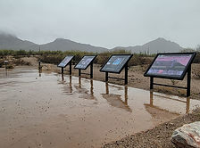
The Titan II Missile Interpretive Site inside the Ironwood Forest National Monument near Marana, Arizona is one of 18 former nuclear missile launch sites that once ringed Tucson during the Cold War — a decommissioned silo where a 9-megaton warhead sat on 58-second launch readiness for over 20 years, now open to the public as a free interpretive site.
#Exploring, #Desert, #Historical

Arizona
Abandoned & Ghost Towns
Ancient Ruins
Caves
Desert
Forest
Historical
Hot Springs
Lakes & Rivers
National & State Parks

Peaks