

AtoZ Bucket List
"Where have you been?"

Featured Video

AZ Places
This is our personal record of places explored — not a curated list from a travel site, but real trips, real roads, and real firsthand experience. Forests, deserts, lakes, rivers, hot springs, caves, peaks, ghost towns, ancient ruins, and more. Arizona, Utah, New Mexico, and beyond. Go find your next one.


Abandoned & Ghost Towns

Ancient Ruins

Caves

Desert

Forest

Historical

Hot Springs

Lakes & Rivers

National & State Parks

Peaks
Muley Point


Muley Point on Cedar Mesa near Mexican Hat, Utah is one of the finest and least known dispersed camping overlooks in the American Southwest — perched 2,400 feet above the San Juan River canyon on BLM land with panoramic views stretching to Monument Valley, the Goosenecks, Valley of the Gods, and the Four Corners region, accessible via a five-mile gravel road with no fees and no reservations.
#BLM, #Camping, #Desert, #Exploring, #Photography, #River, #Wildlife, #Views, #StarGazing
Navajo Bridge — Marble Canyon


Navajo Bridge at Marble Canyon, Arizona spans the Colorado River 467 feet above the water — one of only seven crossings of the river for 750 miles, with two steel arch bridges side by side, a free interpretive center, and some of the most dramatic canyon views in the Southwest accessible to anyone willing to walk out onto the 1929 historic pedestrian bridge.
#Desert, #Exploring, #Historical, #River, #Views, #Wildlife, #Photography
Navajo Moenave Dinosaur Tracks


The Navajo Moenave Dinosaur Tracks near Tuba City, Arizona preserve hundreds of authentic Early Jurassic footprints embedded in 200-million-year-old sandstone — walked among in the open desert with Navajo guides from the community of Moenave, no glass cases, no barriers, no crowds. Just the tracks and the landscape where they were made.
#Desert, #Exploring, #NavajoNation
Navajo National Monument

Navajo National Monument in northern Arizona preserves three of the most intact Ancestral Puebloan cliff dwellings in the Southwest — Betatakin, Keet Seel, and Inscription House — set within the dramatic Tsegi Canyon system on the Navajo Nation, with free entry, free camping, and ranger-led tours to dwellings last occupied around 1300 AD.
#Ancient Ruins, #Desert, #Exploring, #Historical, #Hiking, #NationalMonument, #NavajoNation, #Petroglyphs, #Photography, #Wildlife
Oak Creek (Midgley Bridge)

The Midgley Bridge swimming hole on Oak Creek in Sedona is one of the most beautiful and accessible creek experiences in Arizona — reached by a short descent on the Midgley Bridge Trail and Huckaby Trail, with red rock narrows, natural water chutes you can ride, deep swimming holes, and canyon views that rival anything Slide Rock has to offer with a fraction of the crowds.
#Desert, #Hiking, #River, #Recreation, #Photography, #Wildlife
Oak Creek (Red Rock Crossing)

Red Rock Crossing on Oak Creek near the Village of Oak Creek is one of the most iconic and photographed views in Arizona — Cathedral Rock rising 1,515 feet above the creek, reflected in pools of clear water, accessible via the Baldwin Trail from Verde Valley School Road with swimming holes, Buddha Beach, sand banks, and the kind of day that ends with a double rainbow if you stay long enough.
#Desert, #Exploring, #Fishing, #Hiking, #Photography, #Recreation, #River, #Wildlife
Old Rim Road (FR 171)


Escape into Arizona’s rugged high country along FR 171 and Young Road, where peaceful pine forests, dispersed campsites, and rim-edge views invite backcountry adventure. Located within easy reach of Willow Springs Lake for fishing and picnics, this quieter alternative to the main Rim Road is perfect for wildlife watching, off-grid camping, and exploring the cool, scenic landscapes of the Mogollon Rim region.
#Camping, #Forest, #Hiking, #Recreation, #MogollonRim, #ApacheSitgreaves
Organ Pipe Cactus National Monument
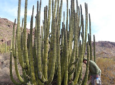
Organ Pipe Cactus National Monument along Arizona's border with Mexico is the only place in the United States where the organ pipe cactus grows wild — a UNESCO biosphere reserve of 330,000 acres protecting one of the most biologically diverse stretches of Sonoran Desert on earth, with 1,700 species of plants and animals, historic ranch homesteads, a natural arch, the Kris Eggle Visitor Center, and Twin Peaks Campground surrounded by saguaro, cholla, ocotillo, and the namesake organ pipe cactus in every direction.
#Hiking, #Camping, #SonoranDesert, #NationalMonument, #GhostTown, #Cave, #Recreation, #Desert
Palatki Heritage Site

Palatki Heritage Site is one of the largest and best-preserved Sinagua cliff dwelling complexes near Sedona, Arizona — featuring ancient rock art, pictographs up to 6,000 years old, and guided tours through red sandstone alcoves in the Coconino National Forest.
#Ancient Ruins, #Petroglyphs, #CoconinoNationalForest
Peralta Regional Park

Peralta Regional Park is a Pinal County gem nestled against the Superstition Mountains near Gold Canyon — offering 31 remote campsites, 9+ miles of multi-use trails, a stargazing node, and a gateway to the Superstition Wilderness.
#Desert, #Camping, #Exploring, #Hiking, #Photography, #Wildlife
Petrified Forest National Park
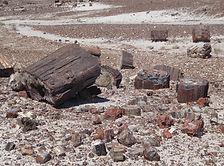
Petrified Forest National Park in northeastern Arizona preserves one of the world's largest and most colorful concentrations of petrified wood — 225 million years old — alongside the sweeping multicolored badlands of the Painted Desert, ancient petroglyphs, and Ancestral Puebloan ruins across 93,500 acres.
#Desert, #NationalPark, #Historical, #Hiking, #Camping
Picacho Peak State Park
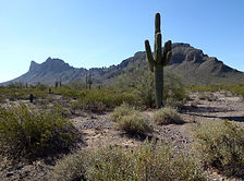
Picacho Peak State Park along Arizona's I-10 corridor is one of the most historically layered state parks in the Southwest — a striking volcanic peak rising 1,500 feet from the Sonoran Desert floor, site of the westernmost battle of the American Civil War, a showcase for spring wildflower blooms that draw visitors from across the state, and a developed campground with 85 electric sites just 45 miles from both Phoenix and Tucson.
#Camping, #Hiking, #ArizonaStateParks, #SonoranDesert, #Desert, #Historical

Arizona
Abandoned & Ghost Towns
Ancient Ruins
Caves
Desert
Forest
Historical
Hot Springs
Lakes & Rivers
National & State Parks

Peaks