

AtoZ Bucket List
"Where have you been?"

Featured Video

AZ Places
This is our personal record of places explored — not a curated list from a travel site, but real trips, real roads, and real firsthand experience. Forests, deserts, lakes, rivers, hot springs, caves, peaks, ghost towns, ancient ruins, and more. Arizona, Utah, New Mexico, and beyond. Go find your next one.

Abandoned & Ghost Towns
Caves
Desert
Forest
Historical & Ancient Ruins
Hot Springs
Lakes & Rivers
National & State Parks
Peaks
Ironwood Forest National Monument
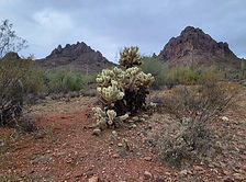


Ironwood Forest National Monument is a protected area located in southern Arizona, United States. It was established in 2000 and covers approximately 129,000 acres of Sonoran Desert landscape. The monument is named after the iconic ironwood trees (Olneya tesota) that grow within its boundaries.
#BLM, #Camping, #RockHounding, #Ancient Ruins, #Petroglyphs, #Desert, #NationalMonument, #Recreation, #Historical
Lava River Cave

This mile-long lava tube cave was formed roughly 700,000 years ago by molten rock that erupted from a volcanic vent in nearby Hart Prairie. The top, sides and bottom of the flow cooled and solidified first, after which the insides of the lava river continued to flow emptying out the present cave.
#Cave, #Camping, #Forest, #Recreation
McFadden Peak

McFadden Peak, the site of one of two fire lookouts in the Sierra Ancha, offers continuous views of the surrounding areas. This peak was named for William McFadden, who started the Circle Ranch on McFadden Creek. McFadden had been part of a vigilante group during the Pleasant Valley War, and later settled in the Sierra Anchas to get away from the feud.
#Hiking, #Forest, #Camping
Meadow Hot Springs
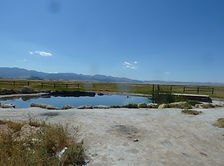

Located just 4 miles south of Fillmore, Utah is the quiet little town of Meadow. Meadow Hot Spring is located just west of the town of Meadow, in an open field. The spring is located on private property, but the land owner has continued to make it accessible to the public. The property has been improved with fences and a nicely graded walking path that connects three different pools. The property owners have posted several signs at the main gate so please respect their wishes and obey the posted rules, this will ensure that this beautiful natural resource will remain open to the public.
#Camping, #HotSprings, #Desert
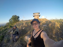
Moqui (FR 95)
FR 95 is a 30-mile forest road corridor through the Coconino National Forest below the Mogollon Rim — offering some of the best dispersed camping in Arizona, with nearby access to East Clear Creek, the historic Moqui Lookout fire tower, Blue Ridge Reservoir, water play in Barbershop Canyon, and miles of ponderosa pine backcountry to explore.
#Camping, #Hiking, #Lake, #MogollonRim, #Forest, #Recreation
Mount Graham (Pinaleño Mountains)

Mount Graham — the 10,720-foot summit of the Pinaleño Mountains — is Arizona's tallest sky island range in the Coronado National Forest near Safford, offering dramatic elevation changes, ancient mixed-conifer forest, Riggs Flat Lake, and some of the most diverse wildlife in North America including the endangered Mount Graham red squirrel.
#Boating, #Camping, #Exploring, #Fishing, #Forest, #Hiking, #Lake, #Photography, #Wildlife
Mt Lemmon

Mount Lemmon is the crown of the Santa Catalina Sky Island — a 9,159-foot escape rising from Tucson's desert floor through six life zones to pine forest, dispersed camping, hiking, and the southernmost ski area in the United States, all accessible via the 27-mile Catalina Highway Scenic Byway.
#Fishing, #Hiking, #Camping, #Lake, #Forest
Navajo National Monument

Navajo National Monument in northern Arizona preserves three of the most intact Ancestral Puebloan cliff dwellings in the Southwest — Betatakin, Keet Seel, and Inscription House — set within the dramatic Tsegi Canyon system on the Navajo Nation, with free entry, free camping, and ranger-led tours to dwellings last occupied around 1300 AD.
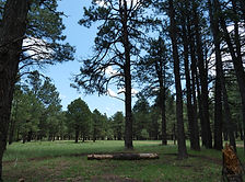
Old Rim Road (FR 171)

Escape into Arizona’s rugged high country along FR 171 and Young Road, where peaceful pine forests, dispersed campsites, and rim-edge views invite backcountry adventure. Located within easy reach of Willow Springs Lake for fishing and picnics, this quieter alternative to the main Rim Road is perfect for wildlife watching, off-grid camping, and exploring the cool, scenic landscapes of the Mogollon Rim region.
#Camping, #Forest, #Hiking, #Recreation, #MogollonRim, #ApacheSitgreaves
Organ Pipe Cactus National Monument
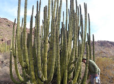
Explore the rugged beauty of Organ Pipe Cactus National Monument, a UNESCO biosphere reserve where vast desert landscapes meet striking mountain ranges. Discover rare flora, hike scenic trails, and experience the vibrant biodiversity of Arizona’s Sonoran Desert.
#Hiking, #Camping, #SonoranDesert, #NationalMonument, #GhostTown, #Cave, #Recreation, #Desert
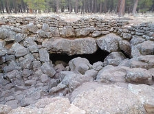
Palatki Heritage Site


Palatki Heritage Site is one of the largest and best-preserved Sinagua cliff dwelling complexes near Sedona, Arizona — featuring ancient rock art, pictographs up to 6,000 years old, and guided tours through red sandstone alcoves in the Coconino National Forest.
#Ancient Ruins, #Petroglyphs, #CoconinoNationalForest


Arizona
Abandoned & Ghost Towns
Caves
Desert
Forest
Historical & Ancient Ruins
Hot Springs
Lakes & Rivers
National & State Parks
Peaks