

AtoZ Bucket List
"Where have you been?"

Featured Video

AZ Places
This is our personal record of places explored — not a curated list from a travel site, but real trips, real roads, and real firsthand experience. Forests, deserts, lakes, rivers, hot springs, caves, peaks, ghost towns, ancient ruins, and more. Arizona, Utah, New Mexico, and beyond. Go find your next one.


Abandoned & Ghost Towns

Ancient Ruins

Caves

Desert

Forest

Historical

Hot Springs

Lakes & Rivers

National & State Parks

Peaks
Happy Jack (FR 81)
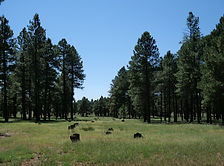


Happy Jack, located in the Mogollon Rim Ranger District of the Coconino National Forest, offers a peaceful escape for dispersed camping. With its cooler summer temperatures, towering pines, and diverse wildlife, it’s a perfect destination for outdoor exploration and relaxation.
#Camping, #CoconinoNationalForest, #Forest, #Hiking, #Recreation
Herb Martyr Campground


Herb Martyr Campground sits at the end of Forest Road 42A in Cave Creek Canyon — a free, primitive campground beside Cave Creek in the Coronado National Forest, where a 12-foot waterfall just below the sites provides one of the most memorable camp soundtracks in southeastern Arizona.
#Camping, #Exploring, #Forest, #Hiking, #Photography, #Recreation, #River, #Wildlife
Homolovi State Park


Homolovi State Park near Winslow, Arizona preserves over 300 ancestral Hopi archaeological sites from the 13th and 14th centuries — including the partially excavated pueblos of Homolovi I and II, pottery shards scattered across the desert floor, petroglyphs, and an exceptional visitor center museum telling the story of the Hisat'sinom people who paused here on their great migration north.
#Ancient Ruins, #ArizonaStateParks, #Desert, #Exploring, #Hiking
Horseshoe Dam & Reservoir

Horseshoe Dam on the Verde River in the Tonto National Forest is one of the Phoenix area's most remote and rewarding destinations — a WWII-era earthfill dam listed on the National Register of Historic Places, where water releases create a rare walk-behind waterfall, and the Verde River below offers dispersed camping, exceptional wildlife, and moonbow nights.
#Camping, #Desert, #Exploring, #Fishing, #Recreation, #River, #Wildlife, #TontoNationalForest, #Photography, #Hiking, #Lake
Hot Well Dunes Recreation Area

Hot Well Dunes Recreation Area near Safford, Arizona is one of the most unusual BLM recreation sites in the Southwest — 2,000 acres of sand dunes for OHV riding alongside two 106°F artesian hot tubs that sprang accidentally from an oil drilling operation in 1928, with camping, wildlife viewing ponds, and a remote desert setting far from anything.
#BLM, #Camping, #Desert, #Exploring, #HotSprings, #Recreation
Howard Pocket (FR 536A)

Howard Pocket is one of eight designated dispersed camping areas on the Coconino National Forest rim above Sedona — a ridge-top camp at over 6,000 feet with sweeping views of the Red Rock-Secret Mountain Wilderness, West Fork Oak Creek Canyon below, and a panorama stretching east to Oak Creek Canyon, I-17, and the fire towers of the Mogollon Rim country.
#Camping, #CoconinoNationalForest, #Forest, #Exploring, #Hiking, #Recreation, #Wildlife, #Photography, #MogollonRim, #Views
Ironwood Forest National Monument
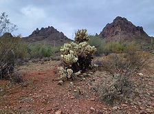
Ironwood Forest National Monument northwest of Tucson covers 129,000 acres of the most biologically dense Sonoran Desert in Arizona — named for the ancient ironwood trees that anchor its desert ecosystem, home to more saguaro per acre than Saguaro National Park, desert bighorn sheep, Hohokam petroglyphs, and unlimited dispersed camping on BLM land with genuine solitude just an hour from Phoenix or Tucson.
#BLM, #Camping, #RockHounding, #Ancient Ruins, #Petroglyphs, #Desert, #NationalMonument, #Recreation, #Historical
Jacks Canyon (FR 230)

Jacks Canyon along FR 230 in the Coconino National Forest south of Flagstaff is a remote and rewarding dispersed camping destination on the Mogollon Rim — a forested canyon corridor with access to Stoneman Lake, Bill Back Butte, Jackson Butte, spring gauge systems, wild foraging, and miles of canyon hiking through washes, rims, and animal trails in classic high-country Arizona.
#Backpacking, #Camping, #Exploring, #Forest, #Hiking, #Historical, #OHV, #OffRoad, #Recreation, #Wildlife, #Views
Jerome State Historic Park


Jerome State Historic Park perches on Cleopatra Hill above the Verde Valley in Jerome, Arizona — home to the 1916 Douglas Mansion, Arizona's largest adobe structure and now a remarkable copper mining museum with period rooms, a 3D model of the underground mines, mineral exhibits, and sweeping panoramic views of the Verde Valley and Sycamore Canyon.
#Exploring, #Historical
Kartchner Caverns State Park

Kartchner Caverns State Park near Benson, Arizona protects one of the most remarkable living cave systems in the world — 2.4 miles of passages discovered in 1974 and kept secret for 14 years to ensure its preservation, featuring Kubla Khan the tallest column in Arizona at 58 feet, a 21-foot soda straw stalactite, and a cave environment maintained at 68°F and 99% humidity year-round through a system of airlocks and misting chambers.
#ArizonaStateParks, #Camping, #Cave, #Desert, #Exploring
Kitt Peak National Observatory

Kitt Peak National Observatory rises to 6,877 feet in the Quinlan Mountains of the Tohono O'odham Nation southwest of Tucson — home to the largest collection of major optical research telescopes on Earth, with daytime tours of historic telescope domes, sweeping Sonoran Desert views, and nighttime stargazing programs that have drawn over 2 million visitors since 1964.
#Exploring, #Historical, #Photography
Lava River Cave
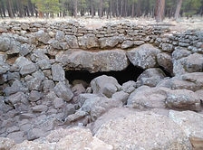
Lava River Cave northwest of Flagstaff is Arizona's longest accessible lava tube — a mile-long underground corridor formed 700,000 years ago when molten rock drained from a solidified outer shell, leaving a dark, cathedral-quiet passage through the Coconino National Forest ponderosa pine country at 7,684 feet.
#Cave, #Camping, #Forest, #Recreation

Arizona
Abandoned & Ghost Towns
Ancient Ruins
Caves
Desert
Forest
Historical
Hot Springs
Lakes & Rivers
National & State Parks

Peaks