

AtoZ Bucket List
"Where have you been?"

Featured Video

AZ Places
This is our personal record of places explored — not a curated list from a travel site, but real trips, real roads, and real firsthand experience. Forests, deserts, lakes, rivers, hot springs, caves, peaks, ghost towns, ancient ruins, and more. Arizona, Utah, New Mexico, and beyond. Go find your next one.


Abandoned & Ghost Towns

Ancient Ruins

Caves

Desert

Forest

Historical

Hot Springs

Lakes & Rivers

National & State Parks

Peaks
Lowell Observatory


Lowell Observatory on Mars Hill in Flagstaff, Arizona is one of the most historically significant astronomical research institutions in the world — a National Historic Landmark where Pluto was discovered in 1930, where the first evidence of the expanding universe was detected in 1912, and where the 24-inch Clark Telescope built in 1896 still operates for public viewing beneath some of the darkest skies in the American Southwest.
#Exploring, #Historical, #StarGazing
Lynx Lake & Lynx Creek


Lynx Lake is a serene 55-acre reservoir at 5,600 feet in the Bradshaw Mountains of the Prescott National Forest — one of central Arizona's most popular recreation areas offering trout fishing, kayaking, hiking, gold panning on Lynx Creek, dispersed camping along FR 30, and a rich mining history stretching back to the first gold discovery in 1863.
#Ancient Ruins, #Boating, #Camping, #Exploring, #Fishing, #Forest, #Lake, #Photography, #RockHounding, #River, #Wildlife, #Recreation
McDowell Mountain Regional Park

McDowell Mountain Regional Park is a 21,099-acre desert jewel in the northeast Valley near Fountain Hills — one of Maricopa County's largest and most scenic regional parks with 50+ miles of hiking, biking, and equestrian trails, sweeping views of the surrounding mountain ranges, and camping options from developed RV sites to primitive tent-only areas.
#Camping, #Desert, #Exploring, #Hiking, #Photography, #Wildlife
McFadden Peak
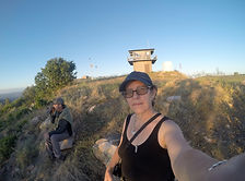
McFadden Peak is one of only two fire lookout sites in the Sierra Ancha wilderness of the Tonto National Forest — a 7,165-foot summit above Pleasant Valley with 360-degree views of one of the most historically significant and remote corners of Arizona, reached by a 2.9-mile round trip hike up Forest Road 561.
#Hiking, #Forest, #Camping
Meadow Hot Springs
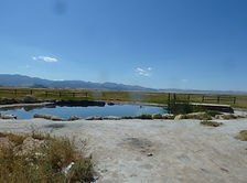

Meadow Hot Springs near Fillmore, Utah is a rare and fragile gift — three clear geothermal pools on private agricultural land, opened to the public through the ongoing generosity of the landowner. The main pool reaches 100°F with remarkable clarity, fish swimming in the cooler pools, and the kind of quiet rural Utah setting that makes a detour off I-15 completely worthwhile. Respect the rules, pack out everything, and help keep this one open.
#HotSprings, #Desert
Mingus Lake & Mingus Mountain

Mingus Lake is a small trout-stocked pond at 7,500 feet on Mingus Mountain in the Prescott National Forest — a quiet day use fishing spot surrounded by ponderosa pines with sweeping Verde Valley views, a campground less than a mile away, and one of the most scenic drives in central Arizona on the way up.
#Camping, #Fishing, #Forest, #Lake, #Photography, #Wildlife
Mogollon Rim — FR 608 (Pine, AZ)


Forest Road 608 on the western Mogollon Rim near Pine, Arizona offers some of the most accessible and rewarding dispersed camping in the Coconino National Forest — rim-edge canyon views, cool ponderosa pine forest at 7,000 feet, wildlife, wildflowers, and classic high-country solitude just 90 minutes from Phoenix.
#Camping, #Forest, #Hiking, #MogollonRim, #CoconinoNationalForest
Montezuma Castle National Monument
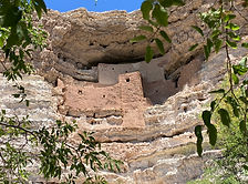
Montezuma Castle National Monument near Camp Verde preserves one of the best-preserved prehistoric cliff dwellings in North America — a five-story, 20-room Sinagua apartment complex notched 90 feet up a limestone cliff above Beaver Creek, designated in 1906 as one of America's first four national monuments and still as remarkable today as when Theodore Roosevelt first protected it.
#Ancient Ruins, #Desert, #Exploring, #Hiking, #Historical, #NationalMonument, #Photography, #Wildlife
Montezuma Well

Montezuma Well near Rimrock, Arizona is one of the most quietly astonishing natural features in the American Southwest — a 368-foot-wide, 55-foot-deep limestone sinkhole discharging 1.5 million gallons of spring water daily, home to five species found nowhere else on Earth, surrounded by 900-year-old Sinagua cliff dwellings and an irrigation canal still carrying water today.
#Ancient Ruins, #Desert, #Exploring, #Historical, #NationalMonument, #Wildlife, #Hiking
Moqui (FR 95)
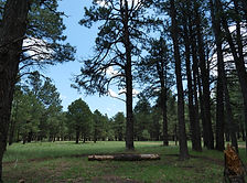
FR 95 is a 30-mile forest road corridor through the Coconino National Forest below the Mogollon Rim — offering some of the best dispersed camping in Arizona, with nearby access to East Clear Creek, the historic Moqui Lookout fire tower, Blue Ridge Reservoir, water play in Barbershop Canyon, and miles of ponderosa pine backcountry to explore.
#Camping, #Hiking, #Lake, #MogollonRim, #Forest, #Recreation
Mount Graham (Pinaleño Mountains)

Mount Graham — the 10,720-foot summit of the Pinaleño Mountains — is Arizona's tallest sky island range in the Coronado National Forest near Safford, offering dramatic elevation changes, ancient mixed-conifer forest, Riggs Flat Lake, and some of the most diverse wildlife in North America including the endangered Mount Graham red squirrel.
#Boating, #Camping, #Exploring, #Fishing, #Forest, #Hiking, #Lake, #Photography, #Wildlife
Mt Lemmon

Mount Lemmon is the crown of the Santa Catalina Sky Island — a 9,159-foot escape rising from Tucson's desert floor through six life zones to pine forest, dispersed camping, hiking, and the southernmost ski area in the United States, all accessible via the 27-mile Catalina Highway Scenic Byway.
#Fishing, #Hiking, #Camping, #Lake, #Forest

Arizona
Abandoned & Ghost Towns
Ancient Ruins
Caves
Desert
Forest
Historical
Hot Springs
Lakes & Rivers
National & State Parks

Peaks