

AtoZ Bucket List
Where have you been?

AZ Places

Peaks

Abandoned & Ghost Towns

Ancient Ruins

Caves

Desert

Forest

Historical

Hot Springs

Lakes & Rivers

National & State Parks
AZ Places
This is our personal record of places explored — not a curated list from a travel site, but real trips, real roads, and real firsthand experience. Forests, deserts, lakes, rivers, hot springs, caves, peaks, ghost towns, ancient ruins, and more. Arizona, Utah, New Mexico, and beyond. Go find your next one.
FILTER
11

Places with camping
Filter
No locations found matching your search. Try adjusting your filters.
McFadden Peak


McFadden Peak is one of only two fire lookout sites in the Sierra Ancha wilderness of the Tonto National Forest — a 7,165-foot summit above Pleasant Valley with 360-degree views of one of the most historically significant and remote corners of Arizona, reached by a 2.9-mile round trip hike up Forest Road 561.

Meadow Hot Springs


Meadow Hot Springs near Fillmore, Utah is a rare and fragile gift — three clear geothermal pools on private agricultural land, opened to the public through the ongoing generosity of the landowner. The main pool reaches 100°F with remarkable clarity, fish swimming in the cooler pools, and the kind of quiet rural Utah setting that makes a detour off I-15 completely worthwhile. Respect the rules, pack out everything, and help keep this one open.
Mingus Lake & Mingus Mountain

Mingus Lake is a small trout-stocked pond at 7,500 feet on Mingus Mountain in the Prescott National Forest — a quiet day use fishing spot surrounded by ponderosa pines with sweeping Verde Valley views, a campground less than a mile away, and one of the most scenic drives in central Arizona on the way up.
Mogollon Rim — FR 608 (Pine, AZ)


Forest Road 608 on the western Mogollon Rim near Pine, Arizona offers some of the most accessible and rewarding dispersed camping in the Coconino National Forest — rim-edge canyon views, cool ponderosa pine forest at 7,000 feet, wildlife, wildflowers, and classic high-country solitude just 90 minutes from Phoenix.
Montezuma Castle National Monument

Montezuma Castle National Monument near Camp Verde preserves one of the best-preserved prehistoric cliff dwellings in North America — a five-story, 20-room Sinagua apartment complex notched 90 feet up a limestone cliff above Beaver Creek, designated in 1906 as one of America's first four national monuments and still as remarkable today as when Theodore Roosevelt first protected it.
Montezuma Well

Montezuma Well near Rimrock, Arizona is one of the most quietly astonishing natural features in the American Southwest — a 368-foot-wide, 55-foot-deep limestone sinkhole discharging 1.5 million gallons of spring water daily, home to five species found nowhere else on Earth, surrounded by 900-year-old Sinagua cliff dwellings and an irrigation canal still carrying water today.
Moqui (FR 95)

FR 95 is a 30-mile forest road corridor through the Coconino National Forest below the Mogollon Rim — offering some of the best dispersed camping in Arizona, with nearby access to East Clear Creek, the historic Moqui Lookout fire tower, Blue Ridge Reservoir, water play in Barbershop Canyon, and miles of ponderosa pine backcountry to explore.
Mount Graham (Pinaleño Mountains)

Mount Graham — the 10,720-foot summit of the Pinaleño Mountains — is Arizona's tallest sky island range in the Coronado National Forest near Safford, offering dramatic elevation changes, ancient mixed-conifer forest, Riggs Flat Lake, and some of the most diverse wildlife in North America including the endangered Mount Graham red squirrel.
Mt Lemmon

Mount Lemmon is the crown of the Santa Catalina Sky Island — a 9,159-foot escape rising from Tucson's desert floor through six life zones to pine forest, dispersed camping, hiking, and the southernmost ski area in the United States, all accessible via the 27-mile Catalina Highway Scenic Byway.
Muley Point

Muley Point on Cedar Mesa near Mexican Hat, Utah is one of the finest and least known dispersed camping overlooks in the American Southwest — perched 2,400 feet above the San Juan River canyon on BLM land with panoramic views stretching to Monument Valley, the Goosenecks, Valley of the Gods, and the Four Corners region, accessible via a five-mile gravel road with no fees and no reservations.
Navajo Bridge — Marble Canyon

Navajo Bridge at Marble Canyon, Arizona spans the Colorado River 467 feet above the water — one of only seven crossings of the river for 750 miles, with two steel arch bridges side by side, a free interpretive center, and some of the most dramatic canyon views in the Southwest accessible to anyone willing to walk out onto the 1929 historic pedestrian bridge.
Navajo Moenave Dinosaur Tracks


The Navajo Moenave Dinosaur Tracks near Tuba City, Arizona preserve hundreds of authentic Early Jurassic footprints embedded in 200-million-year-old sandstone — walked among in the open desert with Navajo guides from the community of Moenave, no glass cases, no barriers, no crowds. Just the tracks and the landscape where they were made.
Navajo National Monument

Navajo National Monument in northern Arizona preserves three of the most intact Ancestral Puebloan cliff dwellings in the Southwest — Betatakin, Keet Seel, and Inscription House — set within the dramatic Tsegi Canyon system on the Navajo Nation, with free entry, free camping, and ranger-led tours to dwellings last occupied around 1300 AD.
Oak Creek (Midgley Bridge)

The Midgley Bridge swimming hole on Oak Creek in Sedona is one of the most beautiful and accessible creek experiences in Arizona — reached by a short descent on the Midgley Bridge Trail and Huckaby Trail, with red rock narrows, natural water chutes you can ride, deep swimming holes, and canyon views that rival anything Slide Rock has to offer with a fraction of the crowds.
Oak Creek (Red Rock Crossing)

Red Rock Crossing on Oak Creek near the Village of Oak Creek is one of the most iconic and photographed views in Arizona — Cathedral Rock rising 1,515 feet above the creek, reflected in pools of clear water, accessible via the Baldwin Trail from Verde Valley School Road with swimming holes, Buddha Beach, sand banks, and the kind of day that ends with a double rainbow if you stay long enough.
Old Rim Road (FR 171)

Escape into Arizona’s rugged high country along FR 171 and Young Road, where peaceful pine forests, dispersed campsites, and rim-edge views invite backcountry adventure. Located within easy reach of Willow Springs Lake for fishing and picnics, this quieter alternative to the main Rim Road is perfect for wildlife watching, off-grid camping, and exploring the cool, scenic landscapes of the Mogollon Rim region.
Organ Pipe Cactus National Monument

Organ Pipe Cactus National Monument along Arizona's border with Mexico is the only place in the United States where the organ pipe cactus grows wild — a UNESCO biosphere reserve of 330,000 acres protecting one of the most biologically diverse stretches of Sonoran Desert on earth, with 1,700 species of plants and animals, historic ranch homesteads, a natural arch, the Kris Eggle Visitor Center, and Twin Peaks Campground surrounded by saguaro, cholla, ocotillo, and the namesake organ pipe cactus in every direction.


Petrified Forest National Park

Petrified Forest National Park in northeastern Arizona preserves one of the world's largest and most colorful concentrations of petrified wood — 225 million years old — alongside the sweeping multicolored badlands of the Painted Desert, ancient petroglyphs, and Ancestral Puebloan ruins across 93,500 acres.
Picacho Peak State Park

Picacho Peak State Park along Arizona's I-10 corridor is one of the most historically layered state parks in the Southwest — a striking volcanic peak rising 1,500 feet from the Sonoran Desert floor, site of the westernmost battle of the American Civil War, a showcase for spring wildflower blooms that draw visitors from across the state, and a developed campground with 85 electric sites just 45 miles from both Phoenix and Tucson.
Pinal Mountains

The Pinal Mountains rise to 7,848 feet just south of Globe, Arizona — a sky island of ponderosa pine and white fir tucked inside the Tonto National Forest, offering cool summer camping, eight hiking trails, sweeping views from the lookout tower and some of the most surprising wildlife encounters in central Arizona.
Pinery Creek

Pinery Creek dispersed camping on FR 42C near Onion Saddle in the Chiricahua Mountains offers one of the most rewarding off-the-beaten-path camp experiences in southeastern Arizona — cliff views at 6,160 feet, a cold clear creek for swimming, an Acorn Woodpecker granary tree right in camp, and the kind of solitude that only comes from finding a place most people drive past.
Red Cliffs Recreation Area

Red Cliffs Recreation Area near Leeds, Utah is a BLM gem tucked against dramatic red sandstone cliffs just off I-15 — featuring Early Jurassic dinosaur tracks in the sandstone, Ancestral Puebloan ruins, 14 hiking trails through Quail Creek Canyon, and one of the most visually striking campgrounds in southern Utah.
Red Rock State Park

Red Rock State Park is Sedona's most serene and family-friendly outdoor destination — a 286-acre nature preserve along Oak Creek where five miles of interconnected trails wind through manzanita and juniper to the creek's lush riparian corridor, framed by the iconic red rock formations that make Sedona famous worldwide.
Riggs Flat Lake

Riggs Flat Lake is an 11-acre alpine lake at 9,000 feet near the summit of Mount Graham in the Coronado National Forest — stocked with rainbow, brown, and brook trout, surrounded by pine forest and meadow, and sitting at the end of the Swift Trail as a reward for the drive up.
Robbers Roost — Hideout Cave
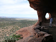
Robbers Roost Trail near Sedona leads to a historic outlaw hideout cave in the red rock country of the Coconino National Forest — a rocky trail through classic Arizona high desert to a cave with framed views of Sedona's red rock cliffs, a dozen or more deer grazing in the canyon below, and dispersed camping available along the adjacent FR 258 Buckboard Road for those looking to stay.
Roosevelt Lake

Roosevelt Lake is Arizona's largest lake entirely within state borders — a 21,000-acre desert reservoir formed by the historic Theodore Roosevelt Dam on the Salt River, offering world-class bass fishing, kayaking, lakeside camping, and sweeping Sonoran Desert views just 90 miles from Phoenix.
Ruby Ghost Town

Just a day trip away from Tucson & 4 miles shy of the border of Mexico is a rare opportunity to look back at over a century of Arizona's mining history. From a once-thriving community of 1,200 people to a modern-day ghost town. Ruby has access to over 350 acres of trails, two lakes, and incredible biodiversity.
Saddle Mountain

Saddle Mountain near Tonopah, Arizona is one of the Phoenix area's most rewarding BLM dispersed camping destinations — a volcanic mountain range at 2,600 feet in the western Sonoran Desert where rockhounds find chalcedony, fire agate, and quartz crystals on the desert floor, ancient petroglyphs mark the volcanic slopes, spectacular sunsets paint the sky, and javelina, jackrabbit, and ocotillo in bloom complete a classic desert spring experience within an hour of the Valley.
Saguaro National Park East

Saguaro National Park East — the Rincon Mountain District — protects one of the densest saguaro forests on earth alongside the 8-mile Cactus Forest Drive, 128 miles of hiking trails, and a wilderness backcountry that climbs from Sonoran Desert to pine forest at 8,666 feet in the Mica Mountains.
Sand Island Petroglyphs

Sand Island Petroglyphs near Bluff, Utah preserves over 100 yards of continuous rock art panel on the banks of the San Juan River — spanning 2,500 to 8,000 years of human history from Archaic hunters to Ancestral Puebloans, Ute, and Navajo peoples, including five Kokopelli figures, San Juan Anthropomorphs, and some of the most accessible ancient rock art in the Bears Ears National Monument region.


Shoofly Village Ruins

Shoofly Village Ruins near Payson, Arizona is one of the most accessible ancient archaeological sites on the Mogollon Rim — a 4-acre prehistoric compound with 80+ rooms, a surrounding stone wall, and interpretive signs that bring a 1,000-year-old community back to life.

Silver Reef Ghost Town

Silver Reef Ghost Town near Leeds, Utah is one of the American West's most geologically unusual mining towns — the only place in history where silver was found in sandstone rather than the quartz or granite that every mining expert of the era insisted was required. Founded in 1875 and abandoned by 1891, the ruins of its stone buildings, original jail, Wells Fargo Express office, mill remains, and pioneer cemetery survive in the red rock landscape of Washington County.
Slide Rock State Park

Slide Rock State Park in Oak Creek Canyon north of Sedona is one of Arizona's most beloved natural attractions — an 80-foot natural sandstone water slide worn slick by Oak Creek, a historic 1912 apple orchard, wading pools, hiking trails, and canyon views that have drawn visitors from around the world since Frank Pendley built his homestead here more than a century ago.
Sunny Flat Campground

Sunny Flat Campground sits at the entrance to Cave Creek Canyon near Portal, Arizona — a well-developed Forest Service campground shaded by sycamores and oaks at 5,200 feet, with canyon wall views, year-round water, and one of the most dramatic lightning and thunderstorm experiences the Chiricahua Mountains can deliver.
Sunset Crater Volcano National Monument

Sunset Crater Volcano National Monument north of Flagstaff preserves the youngest volcano on the Colorado Plateau — a 1,000-foot cinder cone that erupted around 1085 CE, covering 800 square miles in ash and forever changing the lives of the Sinagua people, with dramatic black lava fields, colorful cinder cones, and three short trails through an otherworldly volcanic landscape.
Sycamore Canyon (Parsons Trail)

Parsons Trail is the gateway to Sycamore Canyon Wilderness — Arizona's largest canyon wilderness at 56,000 acres, stretching 21 miles from the Verde Valley floor to the Colorado Plateau rim. A 7.4-mile round trip along Sycamore Creek through towering red sandstone walls leads to Parsons Spring, one of the most rewarding hike-to destinations in central Arizona.
Sycamore Creek (Lower - AZ-87)

Lower Sycamore Creek off AZ-87 near mile marker 212 in the Tonto National Forest is one of the Phoenix area's most rewarding seasonal desert hikes — a canyon creek with wildflowers, swimming holes, a tall waterfall tucked into the rock cliffs, and dispersed camping on sandy washes less than an hour from the Valley.
Tabernacle Hill Lava Tubes

Explore the Tabernacle Hill Lava Tubes in Utah, a captivating natural wonder located near Leeds. This unique geological formation offers adventure seekers a chance to hike, explore underground lava tubes, and take in scenic desert landscapes. Ideal for outdoor enthusiasts, photographers, and campers, the lava tubes are a must-see for those seeking an off-the-beaten-path experience in Southern Utah.
Titan II Missile Interpretive Site

The Titan II Missile Interpretive Site inside the Ironwood Forest National Monument near Marana, Arizona is one of 18 former nuclear missile launch sites that once ringed Tucson during the Cold War — a decommissioned silo where a 9-megaton warhead sat on 58-second launch readiness for over 20 years, now open to the public as a free interpretive site.
Tonto National Monument

The Salado Phenomena, 700 years ago, blended ideas of neighboring Native American cultures to emerge a unique and vibrant society. Tonto National Monument showcases two Salado-style cliff dwellings. Colorful pottery, woven cotton cloth, and other artifacts tell a story of people living and using resources from the northern Sonoran Desert from 1250 to 1450 CE.
Tonto Natural Bridge State Park

Tonto Natural Bridge State Park near Payson, Arizona preserves the largest known natural travertine bridge in the world — a 183-foot high, 400-foot long arch spanning Pine Creek in a hidden canyon of Ponderosa pines, accessible via four short but steep trails that descend to the creek bed, the tunnel beneath the bridge, and swimming holes carved by centuries of mineral-rich water flow.

Tuzigoot National Monument

Tuzigoot National Monument near Clarkdale, Arizona preserves a 110-room Sinagua hilltop pueblo built between 1000 and 1400 CE — one of the best-preserved prehistoric villages in the American Southwest, with sweeping views of the Verde Valley, a museum of 3,000+ artifacts, and a short self-guided loop trail through stone rooms occupied by 250 people for nearly 400 years.
Twin Arrows Trading Post

Twin Arrows Trading Post a Route 66 roadside attraction was built in the late 1940's and was abandoned in 1995. It consists of giant yellow wooden twin arrows, an abandoned gift shop and Valentine’s diner, some gas pumps, and big tanks in the back still remain. The building and various structures are deteriorating, this Icon has certainly seen better days. From what I understand the land is owned by the Twin Arrows Navajo Casino, that appears have yet to cleanup the area. Now abandoned buildings and structures have become a canvas for graffiti artists. Lots of interesting and creative graffiti to explore.

